Map of the Decapolis: Greek Colonies in the Levant

David Chen
Data Visualization Specialist
David Chen is an expert in transforming complex geographic datasets into compelling visual narratives. He combines his background in computer science ...
Geographic Analysis
What This Map Shows
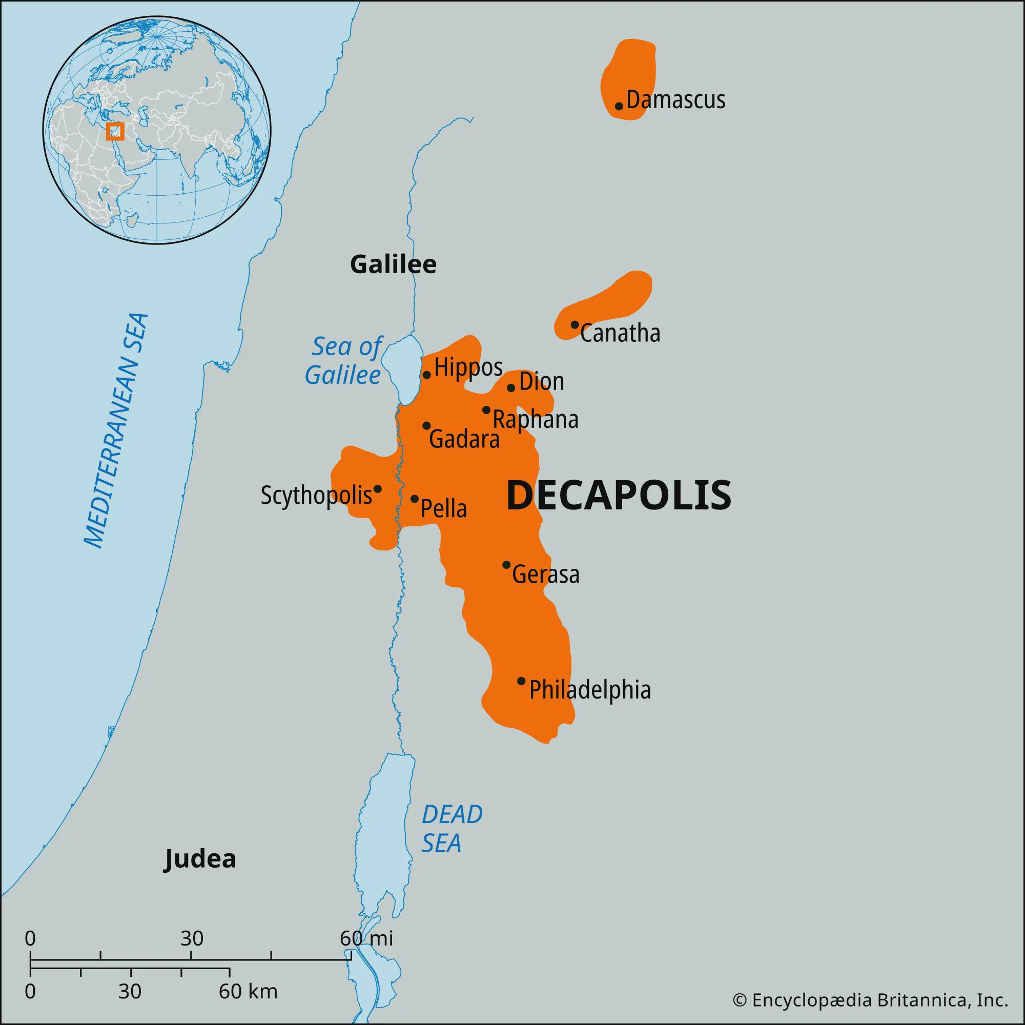
The "Map of the Decapolis" presents a fascinating glimpse into the geographic layout of ten significant Greek cities, known collectively as the Decapolis, located in the Levant region during the Roman Empire. These cities, which include notable locations such as Jerash, Gadara, and Pella, were not just mere settlements; they were vibrant centers of culture, commerce, and governance, autonomous under Roman rule. This visualization effectively captures their geographic distribution and historical context, providing insight into how these cities operated independently from neighboring provinces until the 2nd century.
Deep Dive into the Decapolis
The Decapolis, meaning "ten cities" in Greek, was a remarkable league that emerged during the Hellenistic period and flourished under Roman governance. Ever wondered why these cities were granted such autonomy? It was largely due to their strategic locations along trade routes and their economic contributions to the region. Each city in the Decapolis had its own unique characteristics but shared common cultural and political traits, heavily influenced by Greek and Roman customs.
The ten cities traditionally recognized as part of the Decapolis are: Damascus, Philadelphia (modern Amman), Raphana, Gerasa (Jerash), Gadara, Pella, Scythopolis (Beth Shean), Hippos, Dion, and Canatha. These cities were often situated near key waterways or trade paths, making them critical hubs for commerce and cultural exchange. For instance, the city of Scythopolis, located near the Jordan River, was a vital center for trade and agriculture, while Gerasa became known for its impressive Roman architecture, including theaters and temples.
Interestingly, the governance of these cities allowed them to develop a distinct identity that blended Hellenistic and Roman influences. This autonomy enabled local leaders to impose their own laws and customs, creating a unique society that thrived on trade, art, and philosophy. The urban planning in these cities often featured grid systems, public baths, and marketplaces, which reflected their advanced status compared to other regions of the Levant.
What's fascinating is how the Decapolis cities managed to maintain their autonomy until the 2nd century AD, when the Roman Empire began to exert more control over its provinces. This shift led to increased Roman influence, which altered the cultural dynamics within the cities. However, even with this change, many aspects of Greek culture persisted, echoing through the architecture, language, and daily life of the inhabitants.
Regional Analysis
When analyzing the Decapolis through the lens of the map, one can observe distinct regional characteristics. For example, cities like Damascus and Philadelphia had significant populations and served as administrative centers, while others like Hippos and Gadara were strategically located on elevated terrain, providing military advantages as well as stunning views of their surroundings.
Interestingly, the geographic proximity of these cities to one another facilitated cultural exchanges and economic cooperation. Trade routes connecting these urban centers fostered a sense of community, allowing for the sharing of goods and ideas. For instance, archaeological evidence shows that pottery styles and coinage from one city often appeared in others, illustrating the interconnectedness of their economies.
Moreover, the environmental conditions played a role in how each city developed. For example, the fertile land around the Jordan River supported agriculture, which was particularly important for cities like Scythopolis and Gerasa. In contrast, those cities located in more arid regions, such as Gadara, had to innovate in terms of water management and agriculture, leading to unique adaptations in their urban planning.
Significance and Impact
The significance of the Decapolis extends beyond its historical context; it serves as a reminder of the complexities of cultural identity and governance in ancient times. These cities were not merely outposts of Roman control but rather hubs of innovation and cultural synthesis. Today, the remnants of the Decapolis can be seen in archaeological sites that attract scholars and tourists alike, contributing to our understanding of ancient civilizations.
In contemporary discussions about cultural heritage and preservation, the Decapolis exemplifies the importance of understanding the historical narratives that shaped the region. Current trends in archaeological research focus on uncovering more about these cities, revealing insights into their daily lives, economies, and interactions with surrounding cultures. As we look to the future, the study of the Decapolis reminds us of the dynamic interplay between culture, geography, and history, which continues to influence the Levant today.
In conclusion, the Decapolis offers a rich tapestry of history and culture that is vital for understanding the broader narrative of the ancient world. The map serves not just as a geographical representation but as a portal into the vibrant lives of the people who inhabited these remarkable cities.
Visualization Details
- Published
- September 24, 2025
- Views
- 64
Comments
Loading comments...