Geological Map of the Maltese Islands

David Chen
Data Visualization Specialist
David Chen is an expert in transforming complex geographic datasets into compelling visual narratives. He combines his background in computer science ...
Geographic Analysis
What This Map Shows
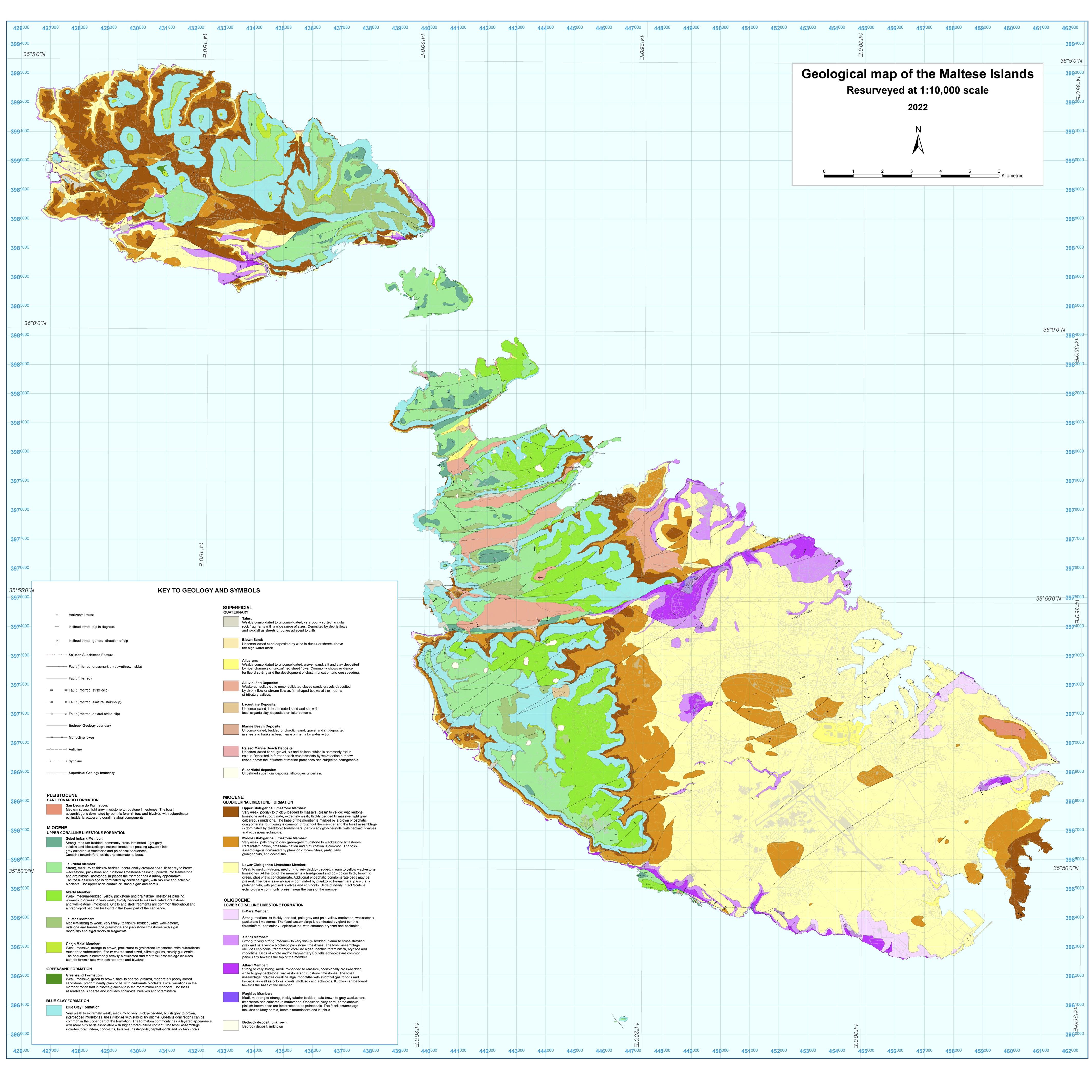
The Geological Map of the Maltese Islands illustrates the diverse geological formations and rock types that make up this archipelago in the central Mediterranean Sea. This visualization provides critical insights into the islands' geological history, showcasing the distribution of various rock strata, fault lines, and sedimentary layers. Malta's geological story is rich and complex, reflecting millions of years of tectonic activity and climatic changes.
Deep Dive into Geology of the Maltese Islands
Malta's geological landscape is predominantly composed of limestone, which is a significant feature of its topography. The islands are primarily made up of two main types of limestone: Lower Coralline Limestone and Upper Coralline Limestone. Interestingly, these limestones were formed during the Late Miocene epoch, around 5 to 10 million years ago, when the area was submerged under a shallow sea. The Lower Coralline Limestone is harder and forms the cliffs along the coastline, whereas the Upper Coralline Limestone is softer and more porous, leading to the formation of valleys and depressions.
But why is this important? The limestone not only shapes Malta's stunning landscapes but also plays a crucial role in the local ecosystems and agriculture. The porous nature of the Upper Coralline Limestone allows rainwater to percolate through, creating a vital aquifer system that supplies fresh water to the islands. This aquifer is essential for sustaining the population, especially given the islands' limited natural water sources.
Additionally, the geological history of Malta provides insights into its past environments. The islands have experienced significant geological events, including tectonic uplift and erosion. The map highlights fault lines that indicate seismic activity, a reminder that Malta lies near the boundary of the African and Eurasian tectonic plates. This positioning has implications not just for the geology but also for the architecture and urban development of the islands, as buildings must be constructed with seismic resilience in mind.
What's fascinating is how Malta's geological features have influenced human settlement and cultural development over the centuries. The famous Megalithic Temples, some of the oldest free-standing structures in the world, were built using local limestone. These ancient structures reflect the ingenuity of early Maltese civilizations, who adapted their architectural techniques to the available geological materials.
Regional Analysis
When examining the geological map closely, we can break down the islands into several distinct regions, each with unique geological characteristics. For instance, the northern part of Malta, including areas like Mellieħa, is characterized by steep cliffs and rugged coastlines, primarily composed of Lower Coralline Limestone. In contrast, the central regions, such as Valletta and Sliema, feature a mix of Upper Coralline Limestone and softer clay deposits, resulting in a very different landscape and urban development.
Gozo, the sister island of Malta, also presents its geological wonders. The famous Azure Window, although collapsed in 2017, was a natural limestone arch formed through the erosion of Upper Coralline Limestone. This region showcases the dramatic impact of geological processes on the landscape and highlights the importance of preserving these natural features.
Interestingly, the geological variations lead to differences in soil quality and agricultural practices across the islands. The fertile soils found in the valleys of Gozo are ideal for growing crops like grapes and olives, while the harsher limestone terrains of Malta often require more sophisticated irrigation techniques to support farming.
Significance and Impact
Understanding the geology of the Maltese Islands is not merely an academic exercise; it has real-world implications for environmental management, urban planning, and cultural heritage preservation. As climate change continues to pose threats such as rising sea levels and increased erosion, knowledge of geological structures is vital. For instance, urban planners must consider the underlying limestone formations when developing infrastructure to ensure stability and sustainability.
Moreover, Malta's geological heritage is a significant aspect of its identity and tourism appeal. The islands attract millions of visitors annually, drawn by their rich history and unique landscapes. Preserving these geological features is crucial not only for environmental reasons but also for maintaining the cultural and historical significance that they embody.
In conclusion, the Geological Map of the Maltese Islands serves as a gateway to understanding the intricate relationship between the land and its inhabitants. By studying the geology, we can appreciate how the natural environment shapes human activity and vice versa, highlighting the importance of sustainable practices to protect this unique Mediterranean gem for future generations.
Visualization Details
- Published
- September 24, 2025
- Views
- 66
Comments
Loading comments...