Map of Amerindian Nations as European Countries

David Chen
Data Visualization Specialist
David Chen is an expert in transforming complex geographic datasets into compelling visual narratives. He combines his background in computer science ...
Geographic Analysis
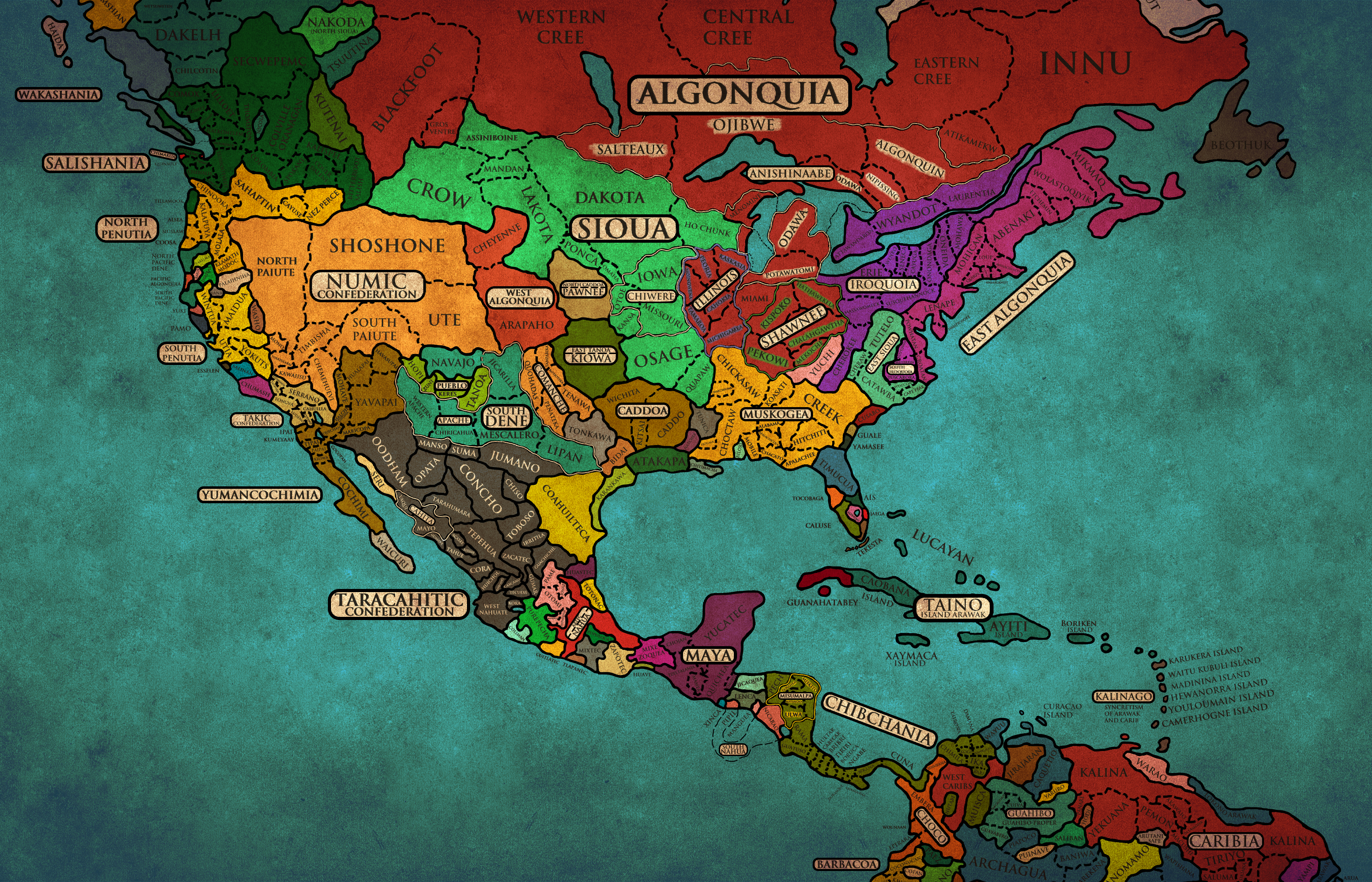
What This Map Shows
This map visualizes contemporary interpretations of historical Amerindian nations, reimagining them as European-style countries. Each country is depicted as an amalgamation of related tribes that once thrived in the Americas. This creative approach serves to highlight the significant cultural and territorial legacies of over 1,500 tribes that have survived from the pre-colonial era into the present day. The territories illustrated approximate those of the tribes that existed around the 1500s, showing their historical presence in contrast to modern nation-states.
Deep Dive into Amerindian Nations
Focusing on the Amerindian nations represented in this map, we see a diverse tapestry of cultures and histories. The Indigenous peoples of the Americas were not monolithic; rather, they encompassed a vast array of languages, traditions, and social structures. Before European contact, it is estimated that there were over 2,000 distinct tribes. However, the impact of colonization drastically altered the demographics and territorial claims of these groups.
Interestingly, many tribes were nomadic, adapting their lifestyles based on the environment, which included forests, plains, deserts, and rivers. For instance, the Plains tribes, such as the Lakota and Cheyenne, were known for their buffalo-hunting culture, while the Iroquois in the Northeast developed complex political systems and agriculture.
The survival of 1,500 tribes today reflects both resilience and adaptation, as many have integrated with other cultures, forming mestizo and creole identities. The map serves as a poignant reminder of this rich heritage, offering a glimpse into the geographical roots of contemporary Indigenous communities. Furthermore, the territories on the map show how historical boundaries often do not align with current nation-states, emphasizing the displacement and ongoing struggles of these groups to assert their identity and land rights.
From a demographic perspective, the current populations of these nations vary widely. For example, the Navajo Nation, one of the largest tribes in the United States, spans parts of Arizona, Utah, and New Mexico and has a population of over 300,000. In contrast, some tribes have significantly smaller populations, often under 1,000, due to historical traumas such as displacement and assimilation.
Regional Analysis
When analyzing the regions depicted in the map, it becomes clear that geographical factors heavily influenced the cultural and social structures of various tribes. In the northeast, tribes like the Algonquin and Iroquois established densely populated villages and engaged in agriculture, facilitated by the rich soils of the region. Conversely, in the arid southwest, tribes such as the Hopi and Zuni developed intricate irrigation systems for farming in a challenging environment.
The Plains tribes, as mentioned earlier, relied heavily on the buffalo for sustenance, which dictated their nomadic lifestyle. The Great Basin tribes, including the Shoshone and Paiute, adapted to their surroundings by focusing on foraging and hunting, often moving between seasonal camps.
Moreover, the Pacific Northwest tribes, like the Tlingit and Haida, thrived on the abundant marine resources, leading to a strong maritime culture that heavily influenced their social organization and art forms. Each region's unique environmental characteristics helped shape the tribes' identities and cultural practices, and this diversity is reflected in the map's representation of Amerindian nations.
Significance and Impact
Understanding this map has crucial implications for recognizing the historical injustices faced by Indigenous peoples. The ongoing struggles for land rights, cultural preservation, and political representation are rooted in the historical displacement of these tribes. Many communities continue to fight for recognition and autonomy, seeking to reclaim their cultural heritage and rights to their ancestral lands.
In contemporary society, there is a growing recognition of Indigenous rights and the importance of cultural preservation. Movements advocating for the rights of Amerindian nations are gaining momentum, emphasizing the need for respect and acknowledgment of their historical territories. Furthermore, as discussions around reconciliation and reparations evolve, understanding the historical context of these tribes becomes even more vital.
As we reflect on this map, it's essential to appreciate the complex interplay between geography and identity. The territories depicted are more than just lines on a map; they represent the enduring legacy of cultures that have shaped the Americas and continue to influence modern society today. The journey toward recognizing and respecting these nations is ongoing, and it starts with acknowledging their historical presence and contributions.\n
Visualization Details
- Published
- September 23, 2025
- Views
- 62
Comments
Loading comments...