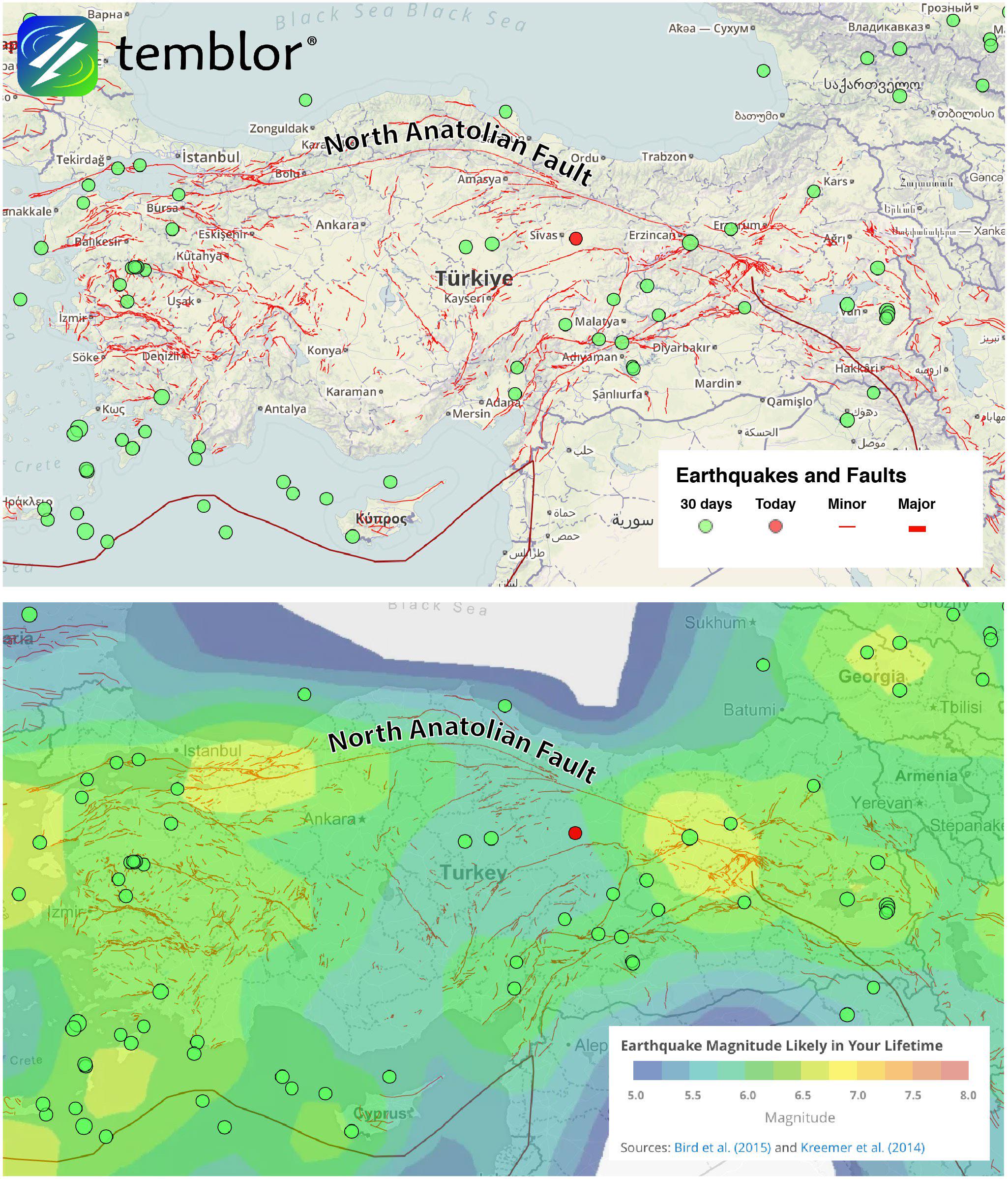
Turkey Fault Map

Marcus Rodriguez
Historical Geography Expert
Marcus Rodriguez specializes in historical cartography and geographic data analysis. With a background in both history and geography, he brings unique...
Geographic Analysis
What This Map Shows
The Turkey Fault Map visually represents the major fault lines that traverse the country, highlighting areas of tectonic activity. This map is crucial for understanding the geophysical landscape of Turkey, which sits at the convergence of several significant tectonic plates, including the Anatolian, Eurasian, and Arabian plates. As you explore this map, you'll notice the prominent North Anatolian Fault (NAF) and the East Anatolian Fault (EAF), which are instrumental in shaping the region's seismic behavior.
Deep Dive into Tectonic Activity in Turkey
Tectonic activity in Turkey is a fascinating subject, primarily due to its unique geographical position. The North Anatolian Fault, which runs parallel to the northern border of Turkey, is one of the most active and studied fault systems in the world. Stretching approximately 1,200 kilometers, the NAF has a history of significant earthquakes, including the devastating 1999 İzmit earthquake, which claimed thousands of lives and caused extensive damage.
Interestingly, the movement of the Anatolian Plate is predominantly lateral, sliding westward at a rate of about 2 to 3 centimeters per year. This movement causes stress to build up along the fault lines, leading to sudden releases of energy in the form of earthquakes. The East Anatolian Fault, while less studied than its northern counterpart, also poses a considerable risk, especially for the southeastern regions of Turkey.
The geological makeup of Turkey is predominantly characterized by a complex interplay of various rock types, including sedimentary, metamorphic, and igneous rocks, formed through millions of years of geological processes. This diversity contributes to the seismic activity observed today. In fact, the region has experienced numerous major earthquakes throughout history, and scientists predict that future seismic events will continue to shape the landscape.
Beyond the immediate effects on human settlements and infrastructure, these tectonic movements also influence the country's geology and natural resources. For instance, the fault systems can lead to the formation of mineral deposits, impacting local economies. Furthermore, understanding the fault lines is crucial for urban planning and disaster preparedness, especially in densely populated areas.
Regional Analysis
When analyzing the Turkey Fault Map, it's essential to consider the regional differences in seismic risk. Northern Turkey, particularly around cities like İstanbul and İzmit, is at the highest risk due to proximity to the North Anatolian Fault. Here, the urban infrastructure must be designed to withstand potential earthquakes, leading to rigorous building codes and regulations.
In contrast, the eastern regions, like Elazığ and Malatya, are influenced by the East Anatolian Fault, which presents its own challenges. While these areas may experience fewer earthquakes compared to the north, the nature of the seismic activity can differ, leading to different types of potential disasters. The geographical and geological variations across Turkey mean that earthquake preparedness must be tailored to each specific region.
Interestingly, the Mediterranean coast, while not as seismically active as the interior, is not immune to tremors. The interactions between the African and Arabian plates can still generate seismic events that impact coastal areas, underscoring the need for comprehensive monitoring and risk assessment throughout the country.
Significance and Impact
Understanding the fault lines in Turkey is crucial not only for the safety of its residents but also for the broader implications on infrastructure, urban development, and environmental management. As cities continue to grow, ensuring that they are earthquake-resistant becomes paramount. The Turkish government has invested in various earthquake preparedness programs, including early warning systems and public education campaigns, to mitigate the impact of potential seismic events.
Moreover, with climate change posing additional challenges, the interplay between environmental factors and geological activity could alter seismic risk in unforeseen ways. For instance, increased rainfall and changes in land use can affect soil stability and potentially trigger landslides in fault-prone areas.
In conclusion, the Turkey Fault Map is not just a representation of geological features; it serves as a critical tool for understanding the complex relationship between tectonic activity and human life in Turkey. By remaining vigilant and informed about these fault lines, residents and policymakers can better prepare for the inevitable seismic events that lie ahead.
Visualization Details
- Published
- September 22, 2025
- Views
- 64
Comments
Loading comments...