Venetian Domains of the Adriatic Map

David Chen
Data Visualization Specialist
David Chen is an expert in transforming complex geographic datasets into compelling visual narratives. He combines his background in computer science ...
Geographic Analysis
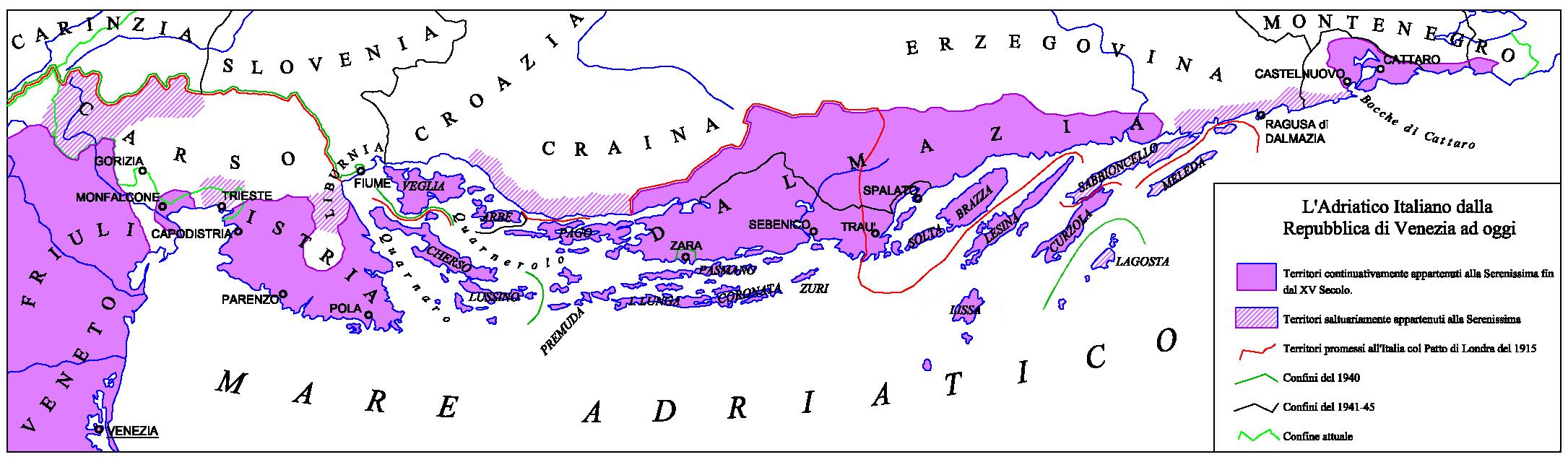
What This Map Shows
The "Venetian Domains of the Adriatic" map highlights the historical territories and maritime influence of the Republic of Venice during its peak from the 13th to the 17th centuries. This visualization illustrates not only the geographic expanse of Venetian control but also the strategic locations of key trade routes and city-states along the Adriatic Sea. As you delve into this map, you’ll notice how Venice's power radiated outwards, impacting various coastal regions and islands, shaping the economic and cultural landscape of the Adriatic.
Deep Dive into the Venetian Domains
The Republic of Venice was a maritime powerhouse, and its domains extended far beyond the modern-day borders of Italy. At its zenith, Venice controlled significant portions of the Adriatic Sea, including parts of present-day Slovenia, Croatia, and Montenegro. The Venetian influence was not merely territorial; it was also deeply entrenched in trade, culture, and politics.
Historically, Venice's economy thrived on trade, particularly in goods such as spices, silk, and precious metals. The Republic established numerous trade routes that connected Europe with the East, and its strategic location at the head of the Adriatic Sea allowed it to dominate maritime commerce. The map illustrates key cities like Dubrovnik, Zadar, and Trieste, which were critical to Venetian trade networks. Interestingly, many of these cities, while part of the Venetian Empire, retained their unique cultures and governance structures, creating a rich tapestry of influences that persists today.
What’s fascinating is how the geography of the Adriatic Sea facilitated Venice’s expansion. The sea itself is dotted with islands, many of which became part of Venetian territories. Islands such as Korčula and Hvar were not only valuable for their resources but also served as strategic outposts for controlling maritime traffic.
The Venetian Republic was also a cultural hub, influencing art, architecture, and governance across its domains. The architectural styles seen in many Adriatic cities today still reflect the grandeur of Venice. For example, the Gothic and Renaissance buildings in cities like Split and Kotor bear testament to the enduring legacy of Venetian architecture. This cultural exchange is a reminder of how geography and trade can shape civilizations.
Regional Analysis
When examining the map, it’s essential to break down the Venetian domains into key regions. For instance, the northern Adriatic coast, which includes modern-day Trieste and Pula, was heavily influenced by Venetian commerce and governance. Trieste, in particular, became a vital trading port, benefiting from its proximity to Venice and its strategic location for maritime trade with Central Europe.
Moving south, we find cities like Zadar and Dubrovnik, which were once key players in the Adriatic trade network. Dubrovnik, known for its impressive city walls and as a center of diplomacy, managed to maintain a degree of independence even while under Venetian influence. This contrasts sharply with the more directly controlled territories in Istria, where Venetian laws and customs were strictly enforced.
Interestingly, the islands of the Adriatic, such as Brač and Vis, showcase a different dynamic. While they were part of the Venetian Empire, they served primarily as agricultural hubs, supplying Venice with essential goods. The varied landscapes and economic outputs of these islands highlight the diversity within Venetian domains. Each region had its unique contributions to the Republic, making the map not just a territorial demarcation but a narrative of economic interdependence.
Significance and Impact
Understanding the "Venetian Domains of the Adriatic" map is crucial for appreciating the historical context of the region. The legacy of Venice’s maritime empire is still evident today in the cultural and architectural influences that permeate the Adriatic coast. This historical perspective is essential, especially as we consider contemporary issues such as tourism and cultural preservation in these regions.
In today's globalized world, the lessons from Venice’s trade practices and cultural exchanges remain relevant. Countries along the Adriatic are now part of the European Union, and their economic ties are stronger than ever, reminiscent of the old trade networks. However, modern challenges such as environmental concerns and the impacts of over-tourism also echo the complexities of managing coastal resources that have persisted for centuries.
Looking forward, the future of the Adriatic region will likely continue to be shaped by its historical legacies while adapting to modern realities. As we analyze such maps, we gain insights not only into the past but also into how geographic and cultural factors will influence the regions' development in the years to come.
Visualization Details
- Published
- September 14, 2025
- Views
- 80
Comments
Loading comments...