UN Resolution to Establish a Palestinian State Map

David Chen
Data Visualization Specialist
David Chen is an expert in transforming complex geographic datasets into compelling visual narratives. He combines his background in computer science ...
Geographic Analysis
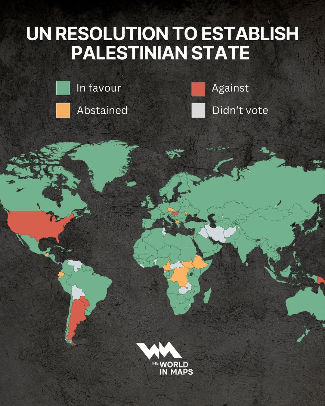
What This Map Shows
This map visualizes the geographical context surrounding the United Nations resolution aimed at establishing a Palestinian state. It highlights the territories proposed for recognition, including the West Bank and Gaza Strip, as well as the significant areas of contention, including the borders, settlements, and key cities. The resolution itself is a pivotal point in Middle Eastern geopolitics, addressing the longstanding Israeli-Palestinian conflict and the quest for Palestinian statehood.
Transitioning from the visual representation, it becomes essential to delve into the broader topic of the Palestinian territories and their significance in this ongoing struggle for statehood. The map not only presents geographical boundaries but also invites us to explore the intricate historical and socio-political dimensions that have shaped these areas.
Deep Dive into the Palestinian Territories
The Palestinian territories primarily consist of the West Bank and Gaza Strip, regions with rich historical, cultural, and political significance. The West Bank is characterized by its mountainous terrain and fertile valleys, while Gaza, a narrow coastal strip, is densely populated and faces numerous socio-economic challenges.
Interestingly, the population of the West Bank is about 2.8 million, while Gaza is home to approximately 2 million people — making it one of the most densely populated areas in the world. The demographics reflect a young population, with a significant portion under the age of 30. However, these territories are not just defined by their geography and demographics; they are also marked by a complex network of political and social dynamics.
The establishment of a Palestinian state, as proposed in the UN resolution, is crucial for addressing issues such as territorial integrity, security, and the rights of refugees. The map indicates various Palestinian cities, including East Jerusalem, which holds profound religious and cultural significance for Palestinians, and is a focal point in discussions about statehood.
Delving into the political dynamics, the Palestinian Authority governs parts of the West Bank, while Hamas controls Gaza. These divisions complicate the peace process and the prospect of a unified Palestinian state. Internationally, the recognition of Palestinian statehood has gained traction, with over 130 UN member states acknowledging it, yet it remains a contentious issue, particularly for Israel and its allies.
Regional Analysis
Examining the map closely, we can categorize the Palestinian territories into several distinct regions, each with its own unique characteristics. In the West Bank, areas such as Ramallah serve as political and administrative centers, while cities like Bethlehem and Hebron are steeped in historical and religious importance.
Interestingly, the area known as Area C, which comprises about 60% of the West Bank, is under full Israeli control, leading to significant restrictions on Palestinian development and movement. This division creates stark contrasts in living conditions and accessibility, affecting economic opportunities and social cohesion.
In Gaza, the situation is even more dire. The ongoing blockade has led to a humanitarian crisis, with high unemployment rates and limited access to essential services. The map highlights the geographic confinement of Gaza, accentuating the urgent need for international dialogue and intervention to alleviate the suffering of its residents.
Significance and Impact
The implications of the UN resolution and the establishment of a Palestinian state are profound. Recognizing a Palestinian state is not merely a matter of politics; it impacts millions of lives and the broader stability of the Middle East. The unresolved status of Palestine contributes to ongoing tensions, violence, and humanitarian crises in the region.
Moreover, global attitudes towards the Israeli-Palestinian conflict are shifting. Recent developments, such as normalization agreements between Israel and several Arab nations, have sparked debates about the future of Palestinian statehood. Some argue these agreements undermine Palestinian claims, while others see them as a potential avenue for renewed negotiations.
In conclusion, the map detailing the UN resolution's context is a visual representation of a complex and deeply rooted geopolitical issue. Understanding the geographical and political landscape of the Palestinian territories is crucial for grasping the challenges and aspirations of the Palestinian people in their pursuit of statehood. As discussions continue, the map serves as a reminder of the urgent need for dialogue, recognition, and ultimately, peace in the region.
Visualization Details
- Published
- September 13, 2025
- Views
- 86
Comments
Loading comments...