Federal Public Land Surface & Subsurface Map

Alex Cartwright
Senior Cartographer & GIS Specialist
Alex Cartwright is a renowned cartographer and geographic information systems specialist with over 15 years of experience in spatial analysis and data...
Geographic Analysis
What This Map Shows
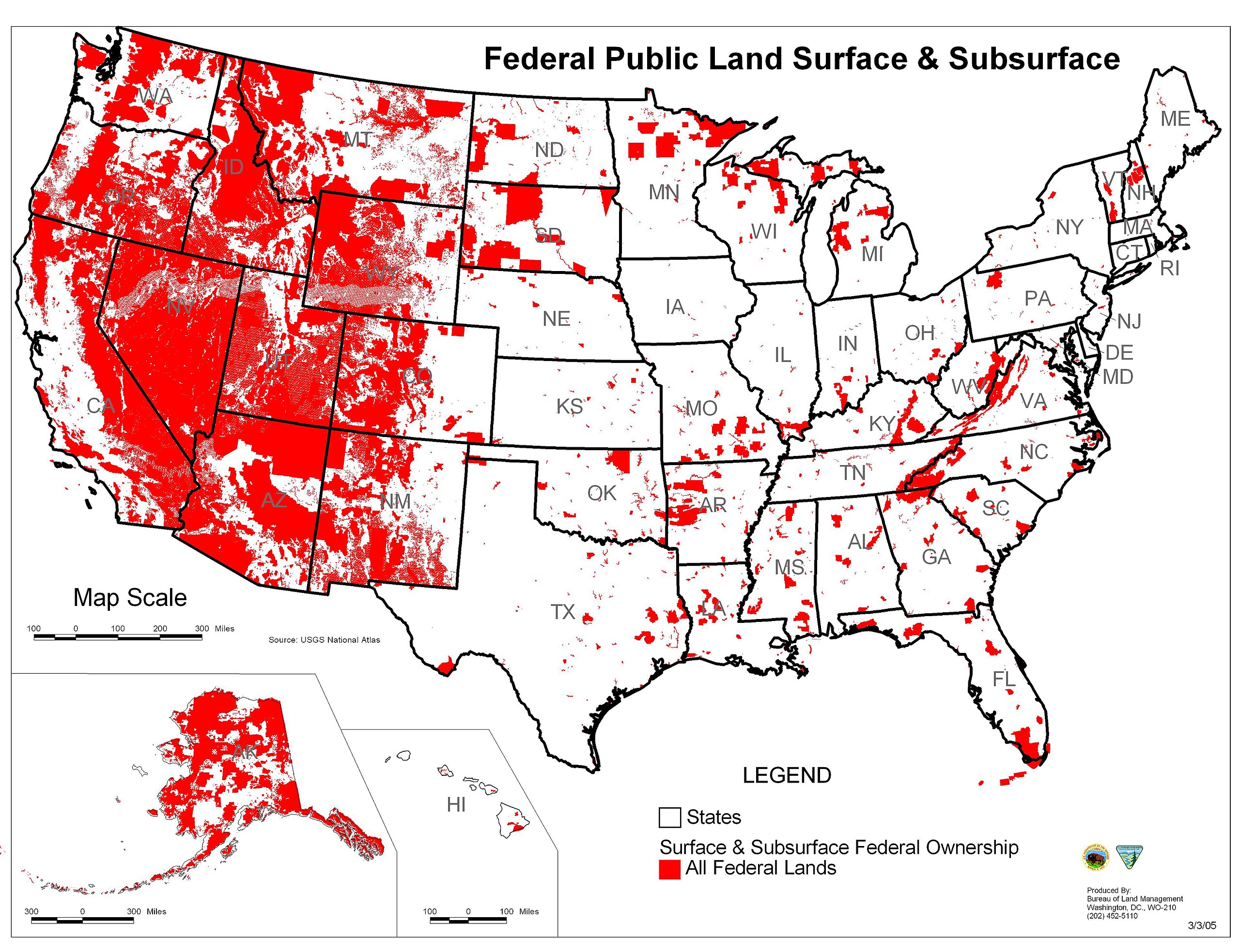
This visualization, titled "Federal Public Land Surface & Subsurface Map," provides a comprehensive overview of the distribution and classification of federal public lands across the United States. It highlights areas managed by various federal agencies and distinguishes between surface and subsurface rights, offering a nuanced perspective on how land is utilized and governed. The map effectively illustrates how these lands serve multiple purposes, from conservation to resource extraction, and the complex legal frameworks that govern them.
Deep Dive into Federal Public Lands
Federal public lands are a significant component of the United States' geographical and ecological landscape. Spanning approximately 28% of the nation’s land area, these lands encompass a variety of ecosystems, ranging from deserts and forests to wetlands and mountains. Managed primarily by the Bureau of Land Management (BLM), the National Park Service (NPS), and the U.S. Forest Service (USFS), these lands are crucial for biodiversity, recreation, and resource management.
Interestingly, the distinction between surface and subsurface rights plays a vital role in how these lands are used. Surface rights pertain to the land's physical attributes, such as the soil, forests, and wildlife. In contrast, subsurface rights involve the minerals and resources found below the surface, including oil, gas, coal, and other minerals. This separation can lead to conflicts, especially in areas where resource extraction is prevalent. For instance, the BLM manages vast tracts of land in the West where subsurface mineral rights are often leased to private companies, while the surface land remains open for public recreational use.
Moreover, the management of these lands is not just about conservation; it also involves striking a balance between development and preservation. For example, the National Parks, managed by the NPS, focus on protecting natural beauty and wildlife habitats, yet they also attract millions of visitors annually, contributing significantly to the local economy. According to the National Park Service, in 2022, the national parks generated over $18 billion in economic benefits, underscoring their importance beyond just ecological values.
Regional Analysis
When analyzing federal public lands on a regional basis, significant variations emerge. The Western United States is home to the largest expanses of federal land, with states like Nevada and Utah having over 80% of their land managed by federal agencies. In contrast, states in the East, such as New Jersey or Connecticut, have a much smaller percentage of federal lands, often limited to specific parks or forests. This distribution speaks to the historical context of land management in the U.S., rooted in the expansion westward.
For example, the Great Basin region, characterized by its arid landscape, is largely comprised of BLM-managed lands. Here, the management strategies are often focused on sustainable grazing and water conservation due to the fragile ecosystem. Conversely, the Appalachian region, rich in biodiversity and forests, is primarily managed by the USFS, which emphasizes recreation and timber management.
In Alaska, federal lands account for about 60% of the state, with vast areas classified as national parks and wildlife refuges. The management of these lands is crucial for wildlife conservation, particularly for species like the polar bear and caribou, which depend on these protected areas for survival.
Significance and Impact
The significance of federal public lands extends beyond mere geography; it encompasses environmental, economic, and cultural dimensions. As climate change accelerates, these lands play a crucial role in carbon sequestration and biodiversity conservation. They serve as critical buffers against climate impacts, providing habitats for wildlife and recreational spaces for people.
However, the future of federal public lands faces challenges. Issues such as land use conflicts, resource extraction, and the push for more development threaten the integrity of these landscapes. The ongoing debates over oil drilling in the Arctic National Wildlife Refuge and the management of public lands in the context of climate change are prime examples of the complexities involved in land governance.
Moreover, public lands are increasingly seen as crucial areas for addressing social justice issues. The call for equitable access to these spaces is growing, with movements advocating for the rights of Indigenous peoples and marginalized communities to have a voice in how these lands are managed and utilized.
As we look ahead, understanding the dynamics of federal public lands is essential. The data presented in the "Federal Public Land Surface & Subsurface Map" serves as a foundation for discussions about preservation, sustainable use, and the future of America’s natural resources. Therefore, it is crucial to advocate for balanced policies that respect both the ecological integrity of these lands and the needs of the communities that rely on them.
Visualization Details
- Published
- September 9, 2025
- Views
- 54
Comments
Loading comments...