Map of the Anglo-Zanzibar War

Marcus Rodriguez
Historical Geography Expert
Marcus Rodriguez specializes in historical cartography and geographic data analysis. With a background in both history and geography, he brings unique...
Geographic Analysis
What This Map Shows
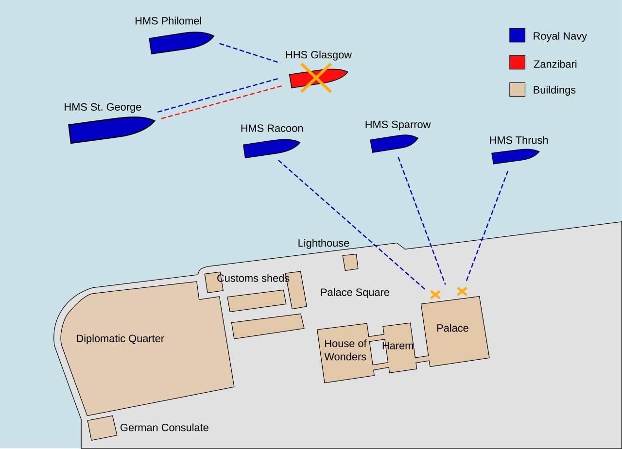
This map provides a detailed overview of the Anglo-Zanzibar War, which is famously known as the shortest war in history, lasting only 38 to 45 minutes on August 27, 1896. The visualization highlights the strategic locations involved in this brief yet significant conflict, primarily focusing on the territories of Zanzibar and British-controlled regions surrounding it. The map illustrates military positions, key landmarks, and the geographical context of the conflict, offering insights into the dynamics that led to this rapid confrontation between the British Empire and the Sultanate of Zanzibar.
Deep Dive into the Anglo-Zanzibar War
The Anglo-Zanzibar War arose from a succession dispute following the death of Sultan Hamad bin Thuwaini. His successor, Sultan Khalid, was not favored by the British, who had vested interests in maintaining their influence over the island. The war itself was a result of the British Empire's efforts to enforce their colonial policies and protect their trade routes in the Indian Ocean.
The conflict was marked by the use of modern naval technology, contrasting dramatically with the Sultan's outdated military capabilities. The British deployed a fleet of warships, including HMS St. George, HMS Philomel, and HMS Sparrow, while the Sultan had a small navy comprising the royal yacht HHS HHS HHS and a few smaller vessels. Interestingly, the map showcases the positions of these ships, providing a visual representation of their strategic roles in the conflict.
One of the defining features of this war was its brevity. The British bombardment began at 9:02 AM, and by 9:40 AM, the Sultan's forces had effectively surrendered. This swift victory underscored the technological disparity between the two sides, highlighting how military advancements can dramatically alter the course of history in a matter of minutes. The map serves as a reminder of how geography and military strategy intersect, as the positioning of forces played a crucial role in the outcome of this war.
Regional Analysis
Zanzibar, an island off the east coast of Africa, is located strategically near major trade routes that connect the African Great Lakes to the Indian Ocean. The map illustrates various regions of Zanzibar, including the capital, Zanzibar City, where the majority of the conflict took place. Comparing the British-controlled areas to the Sultanate's territories reveals a stark contrast in military preparedness and infrastructure.
For example, British-controlled regions benefitted from advanced naval bases and communication lines, allowing for rapid deployment of forces. In contrast, Sultan Khalid's forces were largely composed of local militia with limited access to modern weaponry. The map also indicates the dense urban areas of Zanzibar City, where civilian populations were caught in the crossfire, emphasizing the war's impact on local communities.
What's fascinating is that despite the war's brevity, it had lasting implications for the region. The British solidified their control over Zanzibar, which remained a protectorate until it gained independence in 1963. The map serves not only as a historical reference but also as a geographical testament to the colonial dynamics of the late 19th century.
Significance and Impact
The Anglo-Zanzibar War, while short-lived, is significant for understanding the broader context of imperialism and colonial conflicts during the era. It exemplifies how imperial powers often resorted to military force to resolve disputes and maintain control over territories. The implications of this war extended beyond its immediate aftermath; it set a precedent for future conflicts in the region and influenced local political dynamics.
In today's context, the legacy of such colonial conflicts is still felt in many parts of Africa. The map of the Anglo-Zanzibar War can prompt discussions about the lasting effects of colonialism on national borders, governance, and social structures in post-colonial societies. Current trends suggest a growing interest in revisiting historical conflicts to understand their implications for modern geopolitics and international relations. As we analyze such events through maps, we can better appreciate the intricate tapestry of history and geography that shapes our world today.
Visualization Details
- Published
- September 8, 2025
- Views
- 64
Comments
Loading comments...