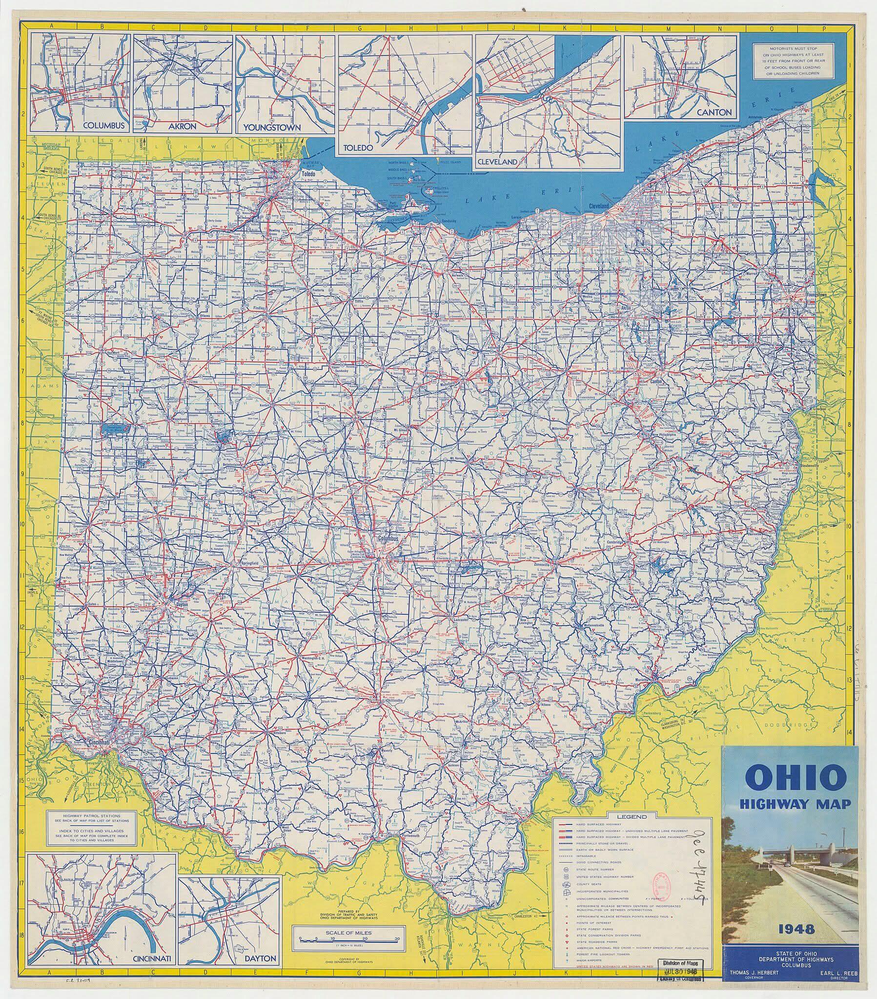
Ohio Highways Map Before the Interstate in 1948

David Chen
Data Visualization Specialist
David Chen is an expert in transforming complex geographic datasets into compelling visual narratives. He combines his background in computer science ...
Geographic Analysis
What This Map Shows
The map titled "Ohio highways before the interstate, as they looked in 1948" provides an intriguing glimpse into the road network of Ohio prior to the establishment of the Interstate Highway System. In 1948, Ohio's highways were primarily a patchwork of state routes, county roads, and local thoroughfares, connecting cities and towns in a manner that reflects the era's transportation priorities. Unlike the modern interstate system designed for high-speed travel and efficiency, these highways were often narrow, winding, and designed for local access rather than long-distance travel.
Deep Dive into Ohio Highways
Interestingly, the development of highways in Ohio has roots that extend back to the early 20th century, when the need for better transportation networks became evident. By 1948, Ohio had established a significant network of highways that laid the groundwork for the future interstate system, which would revolutionize travel in the United States.
Before the interstate system, Ohio's highways were essential for economic growth, connecting urban centers like Cleveland, Columbus, and Cincinnati to rural areas. The routes often reflected the geography of the state, winding through hills, valleys, and farmlands. For instance, U.S. Route 42 and U.S. Route 23 were vital corridors that facilitated both local and regional trade, allowing farmers to transport goods to markets and residents to access urban amenities.
The 1948 map illustrates a mix of paved and unpaved roads, highlighting the challenges of travel at the time. Paved highways offered improved accessibility, but many rural routes remained unpaved, making them susceptible to weather-related disruptions. Picture a journey through the heart of Ohio: one would navigate a series of two-lane highways, possibly encountering livestock, agricultural equipment, and the occasional roadblock due to maintenance or weather conditions.
The post-war era saw a surge in automobile ownership, leading to increased traffic on these highways. However, the limitations of the existing roadways became apparent. Traffic jams, unsafe conditions, and the inefficiency of winding roads necessitated a new approach to highway planning. This led to the eventual creation of the Interstate Highway System initiated in 1956, which aimed to provide faster and safer travel across the nation.
Regional Analysis
Examining the map reveals distinct differences in highway density and type across Ohio's regions. For example, the northwestern part of the state, home to cities like Toledo, boasted a more developed network of highways compared to the southeastern regions, which were more rural and less connected.
In the central region, the highways served as crucial links for commerce and trade. The routes connecting Columbus to nearby suburbs and rural areas were vital for the growth of the state capital, reflecting urban development patterns that favored highway access. Conversely, southeastern Ohio, with its hilly terrain and smaller towns, often relied on less developed roads, which impacted local economies and accessibility.
Interestingly, the map also indicates the early stages of what would become major highways. For instance, parts of today’s Interstate 70 and Interstate 75 are visible in their nascent forms, hinting at the future transformation of Ohio's transportation landscape. The transition from these older highways to the modern interstate routes illustrates not just a shift in infrastructure, but also in societal attitudes toward mobility and connectivity.
Significance and Impact
Understanding the historical context of Ohio's highways before the interstate system is crucial for appreciating the evolution of transportation in the United States. The development of these roadways was intertwined with economic growth, urbanization, and social change. The map serves as a reminder of how infrastructure shapes our daily lives and influences regional development.
Today, we can see the lingering effects of this early highway network in Ohio’s urban planning and economic strategies. The rise of interstate highways led to the decline of many small towns that were once bustling with highway traffic. Many communities now grapple with the challenges of maintaining roadways that no longer serve their original purpose.
As we look ahead, it’s essential to consider how transportation continues to evolve. With the advent of electric vehicles and a push for sustainable transportation solutions, the future of Ohio’s highways may see a reimagining of the very systems that were established in the mid-20th century. By revisiting historical maps like the one from 1948, we can better understand the impact of transportation policies and infrastructure decisions on our communities and environment. The journey of Ohio’s highways is not just about roads; it’s about the people and places they connect, the economy they support, and the future they promise.
Visualization Details
- Published
- September 5, 2025
- Views
- 86
Comments
Loading comments...