Distribution of Hillforts in Ireland Map

Alex Cartwright
Senior Cartographer & GIS Specialist
Alex Cartwright is a renowned cartographer and geographic information systems specialist with over 15 years of experience in spatial analysis and data...
Geographic Analysis
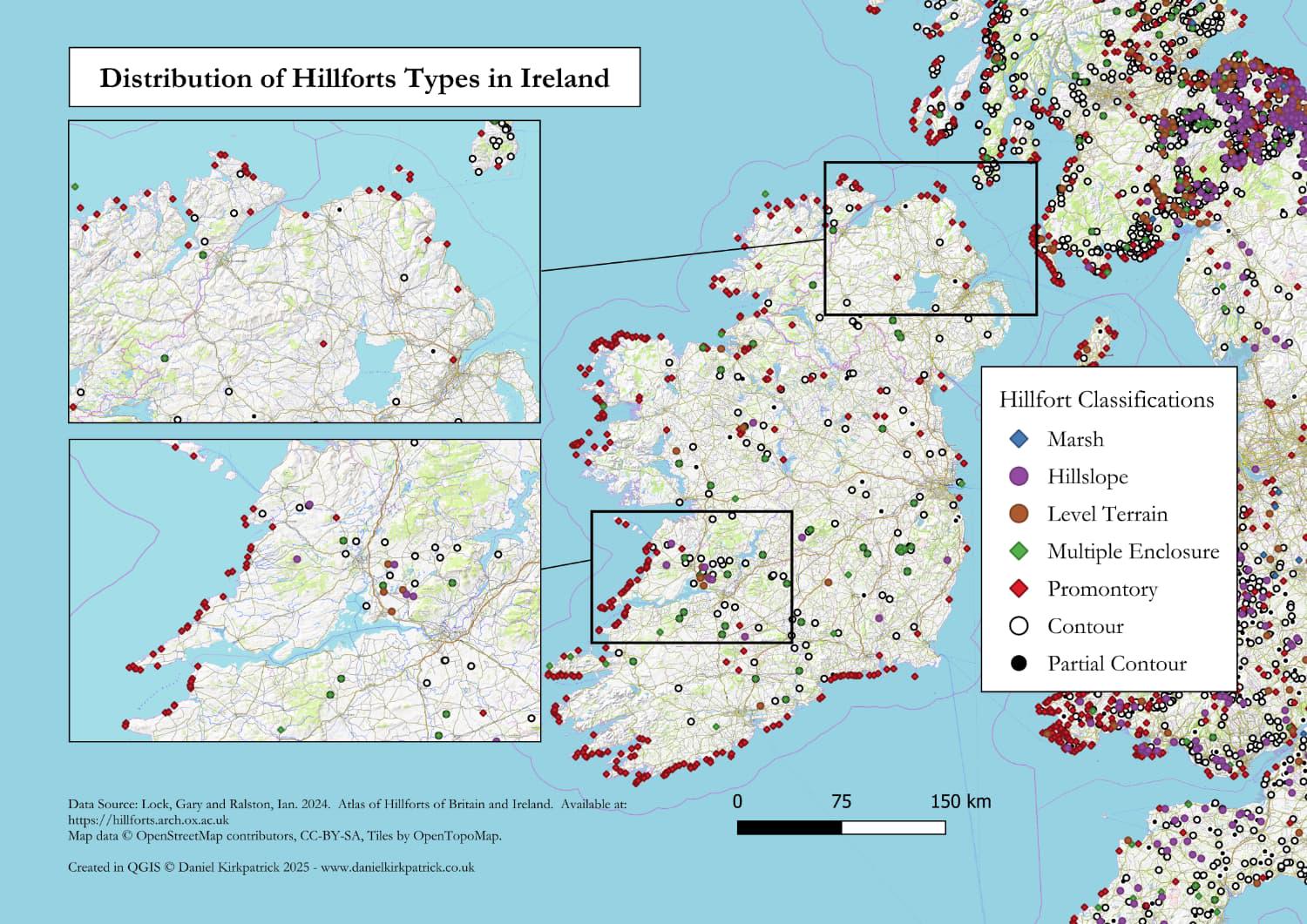
What This Map Shows
The "Distribution of Hillforts in Ireland Map" is a captivating visualization that lays out the locations of various hillforts throughout the Irish landscape. Based on archaeological data from the comprehensive Atlas of Hillforts, this map highlights the classifications of hillforts, offering a clear view of where these ancient structures can be found. From coastal areas to more inland regions, you can see how their distribution reveals insights into historical settlement patterns and defensive strategies utilized by ancient communities.
Deep Dive into Hillforts
Hillforts are fascinating historical structures that were constructed during the Iron Age and earlier. They are typically defined as fortified settlements, often situated on elevated ground, providing both a strategic defensive position and a commanding view of the surrounding landscape. Interestingly, these sites were not only military fortifications but also served as social and economic hubs for ancient communities, where trade and governance flourished.
The construction of hillforts is believed to have begun around 600 BC in Ireland, coinciding with increased social complexity and the emergence of tribal kingdoms. What’s captivating is the diversity in size and structure among hillforts; some are vast, encompassing several acres with multiple enclosures, while others are relatively small, featuring simple earthworks.
Archaeological studies have revealed that these sites were often constructed using earth and timber, with some later incorporating stone. The use of natural resources varied by region, leading to distinct architectural styles that reflect local materials and technologies. Interestingly, the presence of hillforts often correlates with the availability of resources such as fertile land, water sources, and trade routes, which were crucial for sustaining communities.
Statistically, it is estimated that there are over 300 known hillforts in Ireland, with varying degrees of preservation. This number reflects only a fraction of what may have existed, as many sites have been lost to erosion or urban development. Moreover, the map shows a notable clustering of hillforts along the coastal areas of Ireland, suggesting that these locations were strategically advantageous for trade and defense against potential invaders.
Regional Analysis
When examining the map, it becomes apparent that certain regions in Ireland display a higher concentration of hillforts. For instance, the eastern part of the country, particularly in counties such as Meath and Wicklow, showcases a remarkable density of these ancient structures. This region, historically rich and known as the heartland of the Gaelic kings, provides key insights into the socio-political dynamics of ancient Ireland.
Conversely, the western coastal regions, including counties like Clare and Kerry, also reveal significant hillfort distributions. The geographical diversity in these areas, with their rugged terrain and proximity to the Atlantic Ocean, likely influenced the construction and use of hillforts as defensive strongholds against invasions from the sea.
Interestingly, the distribution patterns of hillforts also tell a story of cultural exchange and interaction. Areas with high concentrations of hillforts often correspond to historical trade routes, indicating that these sites served not only as military fortifications but also as meeting places for various tribes and communities.
Significance and Impact
Understanding the distribution of hillforts in Ireland is crucial for several reasons. Firstly, these ancient structures provide invaluable insights into the social, political, and economic systems of early Irish societies. They serve as physical reminders of the complex interactions between communities and their environments.
Moreover, hillforts are significant in the context of heritage preservation. As archaeological sites, they offer opportunities for research and education, enabling us to connect with Ireland's past in a tangible way. However, many hillforts face threats from urbanization, agricultural practices, and climate change, which could lead to further loss of these important cultural landmarks.
Current trends in archaeology emphasize the importance of protecting and studying hillforts, as they hold the keys to understanding early Irish civilization. Future projections suggest that with increased interest and funding for archaeological research, we may uncover even more about these fascinating structures and their role in shaping Ireland's history.
In conclusion, the "Distribution of Hillforts in Ireland Map" does more than just depict locations; it opens a window into Ireland's rich archaeological tapestry. Whether you're a history buff, an archaeology enthusiast, or someone curious about the past, exploring the distribution of hillforts can lead to numerous insights about our shared human story.
Visualization Details
- Published
- September 3, 2025
- Views
- 76
Comments
Loading comments...