China's Overseas Ports Map

Marcus Rodriguez
Historical Geography Expert
Marcus Rodriguez specializes in historical cartography and geographic data analysis. With a background in both history and geography, he brings unique...
Geographic Analysis
What This Map Shows
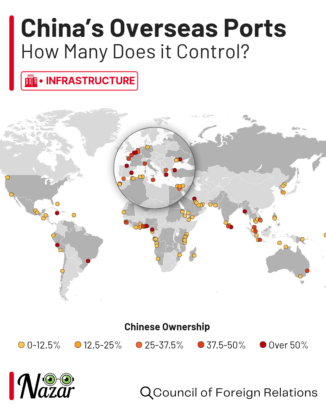
This map illustrates the extensive network of China's overseas ports, highlighting their locations and significance in global trade. As one of the world's largest economies, China has invested heavily in developing ports not just within its borders, but also in strategic locations around the globe. This visualization allows us to see how these ports are distributed and the role they play in international shipping and logistics.
Deep Dive into China's Overseas Ports
China's overseas ports have become vital nodes in the global maritime trade network. These facilities are not just about receiving goods; they are integral to the flow of commerce, facilitating the import and export of a vast array of products. Interestingly, the development of these ports reflects China's broader strategy of expanding its influence on the global stage. One of the most notable initiatives is the Belt and Road Initiative (BRI), which aims to enhance trade routes across Asia, Europe, and Africa.
The ports themselves vary significantly in size and capacity. Major ports such as Gwadar in Pakistan and Hambantota in Sri Lanka are not just commercial hubs; they also serve strategic military purposes. For instance, Gwadar was developed in part to provide China with a foothold in the Arabian Sea, offering a direct route to energy supplies from the Middle East. In contrast, smaller ports may focus on specific sectors, such as fishing or bulk cargo.
Statistically, China's ports rank among the busiest in the world. According to data from the World Shipping Council, Chinese ports accounted for a staggering 36% of the global container port traffic in 2020. This dominance is likely to continue as China pushes forward with its trade strategies. The sheer volume of goods that flow through these ports underscores their importance; for example, the Port of Shanghai, the largest container port globally, handled over 43 million TEUs (twenty-foot equivalent units) in 2021 alone.
Moreover, what's fascinating is how these overseas ports are often interconnected with railways and highways that facilitate the swift movement of goods inland. This logistics infrastructure is essential for the efficient distribution of products not only within China but also to neighboring countries. For instance, the China-Pakistan Economic Corridor (CPEC) connects Gwadar Port to China's Xinjiang region, making it easier to transport goods across borders.
Regional Analysis
When we examine the map more closely, we can identify significant regional clusters of ports. In Southeast Asia, for instance, countries like Malaysia and Indonesia have established partnerships with China to develop their port facilities. The Port of Kuantan in Malaysia, for example, has seen increased Chinese investment and serves as a critical point for shipping routes between East and West.
In Africa, China's investment in ports like Djibouti and the aforementioned Hambantota is aimed at securing trade routes and access to resources. Djibouti, strategically located at the entrance of the Red Sea, is becoming a central hub for maritime trade between Africa and the Middle East, benefiting significantly from Chinese infrastructure development.
Conversely, in Europe, the significance of China's ports is reflected in investments in ports such as Piraeus in Greece. This port has transformed into a primary entry point for Chinese goods into Europe, showing how China is not just exporting products but also importing influence and establishing a foothold in European markets.
Significance and Impact
The significance of China's overseas ports cannot be understated. They are not merely logistical centers; they represent a shift in global trade dynamics, where China is positioning itself as a key player in international shipping. The implications are vast, affecting global supply chains, trade agreements, and even geopolitical relationships.
As we look to the future, trends suggest that China's influence will continue to grow. The ongoing investments in port infrastructure, particularly under the BRI, highlight a long-term strategy to dominate maritime trade routes. However, this expansion is not without controversy. Countries that partner with China often find themselves in complex relationships, balancing economic benefits against potential political and sovereignty issues.
In conclusion, the map of China's overseas ports is not just a collection of dots on a geographical representation; it is a reflection of a rapidly evolving global trade landscape. Understanding these ports and their implications helps us grasp the larger economic and political shifts occurring in the world today. So, next time you consider the products arriving at your doorstep, remember the intricate network of ports that made it possible, many of which are connected to the vast maritime empire that China is building.
Visualization Details
- Published
- August 26, 2025
- Views
- 220
Comments
Loading comments...