Ethnic Composition Map of Austria-Hungary 1910

David Chen
Data Visualization Specialist
David Chen is an expert in transforming complex geographic datasets into compelling visual narratives. He combines his background in computer science ...
Geographic Analysis
What This Map Shows
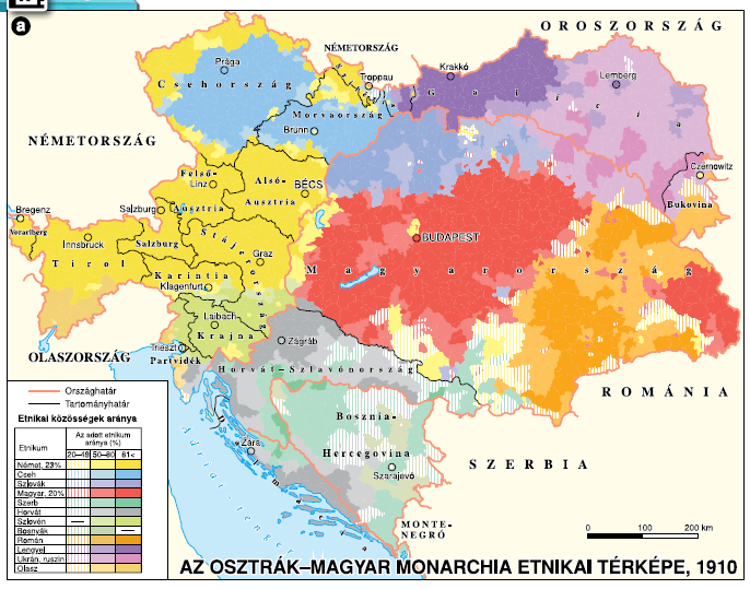
The ethnic composition map of Austria-Hungary around 1910 provides a vivid snapshot of the diverse nationalities that inhabited this sprawling empire at the turn of the 20th century. The map, which is presented in Hungarian, illustrates the distribution of various ethnic groups across the territories of Austria-Hungary, highlighting the intricate mosaic of cultures that characterized this historical region. With a multitude of ethnicities such as Germans, Hungarians, Czechs, Slovaks, Croats, and many others, this map serves as an important tool for understanding the demographic complexities of the empire during a transformative period in European history.
Deep Dive into Ethnic Composition
Diving deeper into the ethnic composition of Austria-Hungary reveals a fascinating interplay of cultures, languages, and identities. By 1910, the Austro-Hungarian Empire was a multi-ethnic state, home to approximately 51 million people, a significant portion of whom were non-Hungarian. The two dominant ethnic groups were the Germans and Hungarians, but the empire was also populated by Czechs, Slovaks, Croatians, Serbs, Romanians, Italians, and Jews, among others.
What's interesting is that the map indicates not just the presence of these groups but also their geographical distribution. For instance, the northern regions, particularly Bohemia and Moravia, were predominantly Czech, while the southern areas, such as Croatia and Slovenia, showcased a strong Slavic presence. In the eastern provinces, especially Transylvania, Romanians were the majority, demonstrating the diverse linguistic and cultural landscape of the empire.
Moreover, the urban centers, such as Budapest, Vienna, and Prague, were melting pots of ethnicities, contributing to a rich cultural exchange. For example, Vienna, with its significant Jewish population, was not only a hub of commerce but also a center for arts and sciences, showcasing contributions from various ethnic backgrounds. However, the map also underscores tensions; the coexistence of so many groups sometimes led to conflicts over national identity and autonomy, which would later escalate into significant political movements.
Interestingly, the distribution of these ethnic groups was influenced by historical migrations, political boundaries, and economic opportunities. Many ethnic groups sought to maintain their cultural identity in the face of pressures to assimilate, leading to a vibrant yet complicated social fabric. The map provides a visual representation of this struggle, illustrating how geography and ethnicity were intertwined in shaping the lives of millions.
Regional Analysis
When we analyze the ethnic distribution by region, the map reveals stark contrasts that underscore the diversity of Austria-Hungary. In the western regions, particularly Upper Austria and Styria, the German population was predominant, while in Lower Austria, there was a mix of Germans and Hungarians, reflecting the empire's dual nature.
Moving towards the central parts of the empire, one can observe a notable Czech majority in Bohemia and Moravia, where national consciousness was beginning to flourish. The Czech lands were also experiencing a cultural renaissance, with movements advocating for greater autonomy and recognition.
In contrast, the southern provinces such as Croatia and Slovenia were predominantly Slavic, with significant historical ties to Serbia. This area was marked by a sense of national awakening, as the Slavic populations increasingly sought political representation and rights, leading to rising tensions with the Austro-Hungarian authorities.
In the eastern reaches of the empire, Transylvania stood out with its diverse ethnic mix, including Romanians, Hungarians, and Saxons. Each group maintained distinct cultural practices and languages, which further complicated the political landscape. The map’s detailed distribution allows for a better understanding of how these regions interacted, not just within the empire but also with neighboring nations.
Significance and Impact
Understanding the ethnic composition of Austria-Hungary in 1910 is crucial for several reasons. First, it sheds light on the challenges faced by multi-ethnic empires, especially in terms of governance and national unity. The tensions between various ethnic groups contributed to the eventual disintegration of the empire after World War I, leading to the formation of several independent nation-states.
What's more, the historical context provided by the map remains relevant today as we witness the ongoing struggles for identity and autonomy in various regions across Europe. The lessons learned from Austria-Hungary's ethnic composition can inform current discussions around immigration, multiculturalism, and national identity. As we analyze the past, we must consider how these historical narratives shape contemporary society, and this map serves as a poignant reminder of the complexity of human relationships across borders.
In conclusion, the ethnic composition map of Austria-Hungary around 1910 not only highlights the diversity of the empire but also illustrates the intricate weave of history, culture, and identity that continues to influence the region today. The legacies of these ethnic groups, their struggles, and achievements are woven into the very fabric of modern Europe, making this map a vital piece of our historical puzzle.
Visualization Details
- Published
- August 24, 2025
- Views
- 170
Comments
Loading comments...