EU Member States by Surface Area Map

David Chen
Data Visualization Specialist
David Chen is an expert in transforming complex geographic datasets into compelling visual narratives. He combines his background in computer science ...
Geographic Analysis
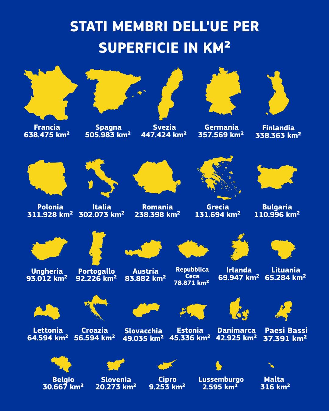
What This Map Shows
The "EU Member States by Surface Area Map" provides a clear and informative visualization of the total land area of each European Union member country. It allows viewers to quickly ascertain how the countries stack up against one another in terms of size, measured in square kilometers. This kind of geographical data is crucial for understanding not just the physical landscape of Europe, but also the geopolitical dynamics and socio-economic implications tied to land area.
Deep Dive into Surface Area of EU Member States
Surface area is a fundamental geographical aspect that influences everything from population density to resource distribution. In the European Union, the total land area varies significantly among member states. For example, France is the largest country in the EU, covering approximately 551,695 km², while Malta is the smallest, with a mere 316 km². This stark difference raises questions about how size correlates with economic power, population, and governance.
Interestingly, larger countries like France and Spain bear a more significant responsibility for environmental management and governance. Their vast landscapes encompass diverse ecosystems ranging from the Mediterranean climate in the south to the temperate zones in the north. In contrast, small countries such as Luxembourg or Malta have less land to manage but may face unique challenges related to urbanization and resource allocation.
The relationship between surface area and population density is also noteworthy. For instance, the Netherlands, though smaller in size than many of its EU counterparts, has a high population density of around 508 people per km², largely due to its urban centers like Amsterdam and Rotterdam. In contrast, Finland, with a larger surface area of 338,424 km², has a much lower population density of approximately 18 people per km². This variation leads to different developmental strategies and urban planning approaches across the continent.
Furthermore, surface area impacts economic activities. Larger countries often have more diverse economies, benefiting from various natural resources and agricultural lands. For example, Poland, with a surface area of 312,696 km², has fertile plains that support extensive agricultural activities, while also housing significant industrial sectors. On the flip side, smaller nations often focus on niche markets or services, as seen in Luxembourg’s financial sector, which thrives despite its limited land area.
Moreover, geography plays a crucial role in cultural identity and tourism. Countries with extensive surface areas such as Italy can boast a variety of landscapes and cultural experiences, from the Alps in the north to the Mediterranean coast in the south. This geographical diversity not only attracts tourists but also fosters a rich cultural heritage that is deeply intertwined with the land.
Regional Analysis
Looking at the EU through the lens of surface area reveals fascinating regional differences. The Nordic countries, including Sweden and Finland, dominate in size, offering vast forests and extensive coastlines. This expansive geography is both a blessing and a challenge, as these nations must balance economic development with environmental preservation.
In Southern Europe, countries like Spain and Italy showcase a different geographical narrative. Their larger land areas contribute significantly to agriculture and tourism, yet they also face challenges like urban sprawl and climate change impacts. Interestingly, Italy’s diverse geography allows for a wide range of agricultural products, from olives in the south to grapes in the north, which are vital for its economy.
Conversely, the Benelux countries—Belgium, the Netherlands, and Luxembourg—demonstrate how smaller nations can still have substantial economic influence. The Netherlands, with its strategic location and extensive port infrastructure, plays a vital role in European logistics despite its smaller land area compared to larger neighbors.
Significance and Impact
Understanding the surface area of EU member states is not merely an academic exercise; it has real-world implications. Land area plays a crucial role in determining resources, governance, and environmental strategies. Countries with larger areas often have to tackle complex issues related to managing diverse ecosystems and resources effectively.
Moreover, as climate change increasingly impacts Europe, the geographical layout of these member states will influence how they adapt. For instance, countries like Greece and Spain, with extensive coastlines, are more vulnerable to rising sea levels, which could affect their tourism-based economies significantly. In contrast, landlocked nations like Austria may face fewer direct impacts from rising sea levels but will still need to address other environmental challenges.
As we move forward into the future, the geographical data illustrated in this map will continue to be vital for policymakers, businesses, and communities. The interplay between surface area and socio-economic factors is a dynamic landscape that will evolve as countries address the challenges of the 21st century. Understanding these relationships is key to fostering sustainable development across Europe, ensuring that both large and small nations can thrive in an interconnected world.
Visualization Details
- Published
- August 19, 2025
- Views
- 96
Comments
Loading comments...