Map of US State Capitals and Largest Cities

Alex Cartwright
Senior Cartographer & GIS Specialist
Alex Cartwright is a renowned cartographer and geographic information systems specialist with over 15 years of experience in spatial analysis and data...
Geographic Analysis
What This Map Shows
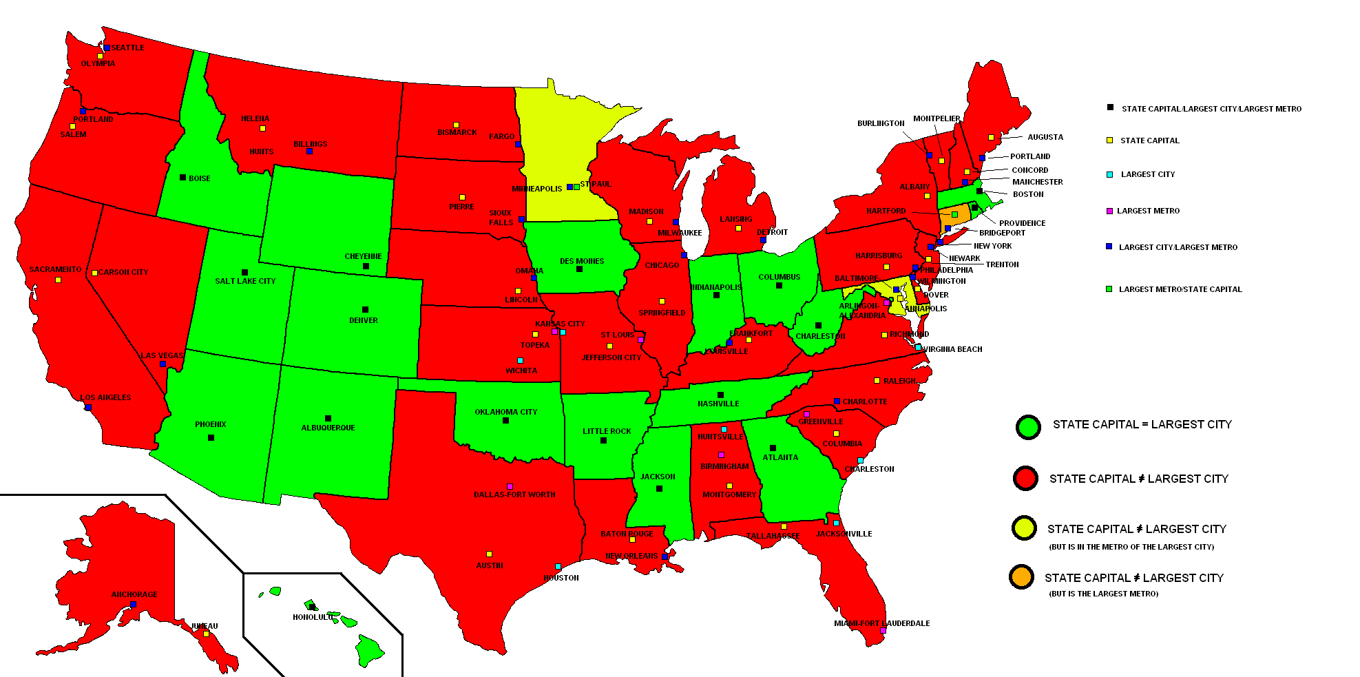
The "Map of US State Capitals and Largest Cities" provides a clear visualization of the political and economic centers across the United States. Each state capital is marked alongside the largest city within that state, highlighting not only the administrative hubs but also the urban areas where most of the population resides. This juxtaposition raises interesting questions about governance, urban development, and the distribution of resources across this vast nation.
Deep Dive into State Capitals and Largest Cities
State capitals serve as the political heart of their respective states. They are often the sites of legislative buildings, governor's offices, and other essential government functions. However, they are not always the most populous cities within the state. For instance, while Phoenix is the capital of Arizona, it also happens to be the largest city, with a population exceeding 1.7 million. In contrast, the capital of Vermont, Montpelier, is not only the capital but also the smallest state capital in the U.S. with a population of just around 7,500 people.
Interestingly, the relationship between a state’s capital and its largest city can reveal much about historical settlement patterns, economic development, and even cultural identity. Many state capitals were chosen for their geographic centrality, making them accessible to residents from across the state. This was particularly important in earlier centuries when travel was less convenient.
Moreover, the economic dynamics of a state can often be traced through its largest cities. States like California and Texas showcase bustling metropolises like Los Angeles and Houston, which serve as major economic engines. In these cases, the largest city often overshadows the capital in terms of population, influence, and economic output. For example, Los Angeles, with a population of nearly 4 million, dwarfs Sacramento, the capital, which has around 500,000 residents.
Statistically, about 30% of state capitals are also the largest cities in their respective states. This dynamic poses interesting questions about urbanization and governance. How do these cities manage the dual roles of being both a political center and a major urban hub? What challenges arise in terms of infrastructure, public services, and representation?
Regional Analysis
By examining the map regionally, we can see distinct patterns emerge. In the Northeast, for example, many state capitals are relatively close in size to their largest cities. Boston, Massachusetts, is both the capital and the largest city, reflecting a historical and cultural significance. Meanwhile, in states like New York, Albany serves as the capital but is significantly smaller than New York City, which is a global metropolis.
Moving to the Midwest, we find a similar trend. Cities like Indianapolis, which is both the capital and the largest city of Indiana, illustrate a cohesive relationship between governance and urban development. In contrast, in states like Michigan, Lansing serves as the capital while Detroit, with its larger population, represents the cultural and economic heart of the state.
In the South, the relationship can be quite varied. For instance, Atlanta is not only the capital of Georgia but also its largest city, embodying a blend of historic significance and rapid urban growth. However, in South Carolina, Columbia serves as the capital while Charleston, known for its rich history and tourism, is the state's largest city.
Significance and Impact
Understanding the relationship between state capitals and their largest cities is more than just an academic exercise; it has real-world implications. These dynamics can influence everything from political representation to resource allocation. For instance, states where the capital is not the largest city may face challenges in terms of public policy that prioritizes urban needs. This can lead to disparities in funding for infrastructure, education, and healthcare.
Moreover, as urban areas continue to grow, the role of state capitals may evolve. With increasing populations in cities, there may be calls for re-evaluating where political power is concentrated. Trends like urbanization and migration patterns can influence future developments and potentially shift the political landscape.
In conclusion, the "Map of US State Capitals and Largest Cities" serves as a valuable tool for understanding not only where power resides but also how cities shape the lives of their residents. As we look to the future, these relationships will continue to evolve, reflecting the changing nature of American society and governance.
Visualization Details
- Published
- August 12, 2025
- Views
- 248
Comments
Loading comments...