Japanese Invasion of China Map

Marcus Rodriguez
Historical Geography Expert
Marcus Rodriguez specializes in historical cartography and geographic data analysis. With a background in both history and geography, he brings unique...
Geographic Analysis
What This Map Shows
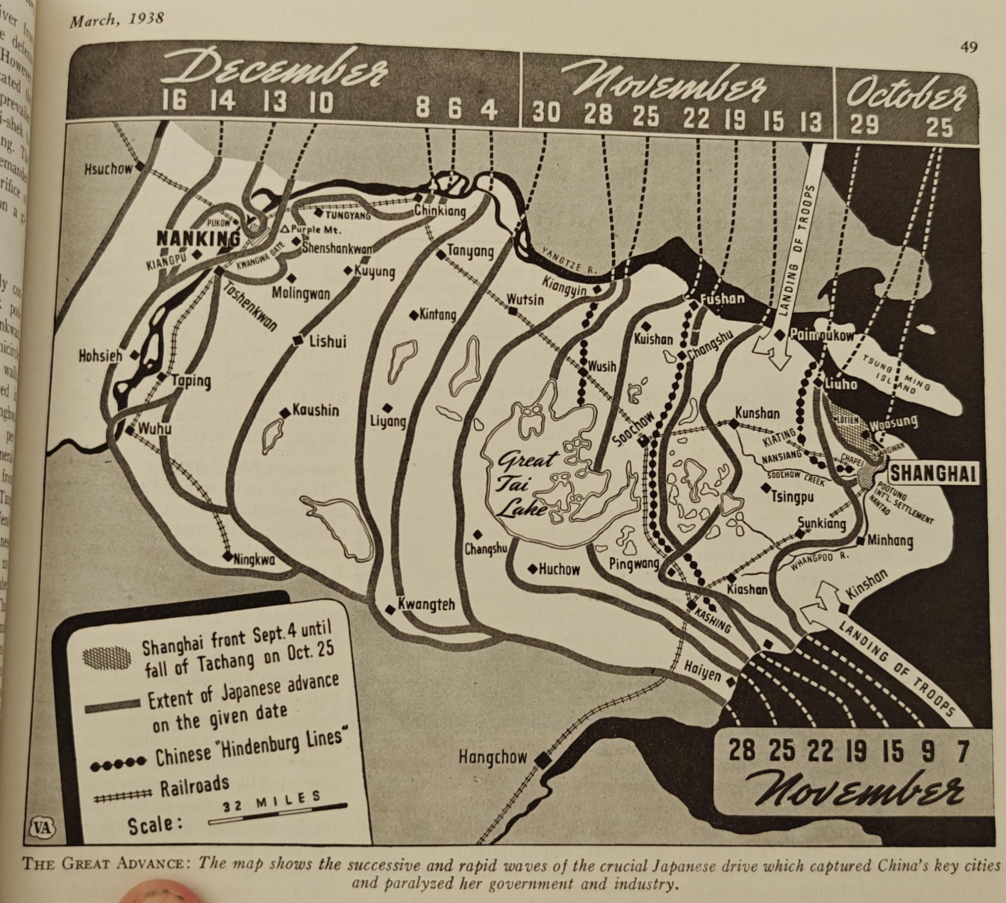
This map provides a detailed overview of the Japanese invasion of China that commenced in late 1937, highlighting significant military movements, key battle sites, and the territorial expansion of Japan during this tumultuous period. It visually represents the conflict's geographical scope, allowing us to understand the strategic importance of various regions in China and how they were impacted by the invasion.
Transitioning from the map itself, we delve into the historical context and the broader implications of this military campaign. The invasion, which began with the Marco Polo Bridge Incident in July 1937, marked the start of the Second Sino-Japanese War, a conflict that would last until the end of World War II in 1945.
Deep Dive into the Japanese Invasion
The Japanese invasion of China was not merely a territorial struggle but a complex interplay of political, economic, and military factors. Japan sought to augment its empire for various reasons, including access to resources and markets. Interestingly, this ambition was intensified by Japan's rapid industrialization and the need for raw materials, particularly during the global economic downturn of the 1930s.
One of the most significant events on the map is the Battle of Shanghai, which took place from August to November 1937. This battle was characterized by fierce urban warfare and resulted in heavy casualties for both the Japanese and Chinese forces. Shanghai, being one of China's largest cities and a vital economic hub, was a strategic target. The Japanese aimed to capture it quickly and establish a foothold in Eastern China to facilitate further advances.
The map also highlights the Nanking Massacre, one of the darkest episodes of the invasion, where Japanese troops captured Nanjing (then spelled Nanking) in December 1937. Estimates suggest that hundreds of thousands of Chinese civilians and disarmed soldiers were killed, and widespread atrocities were committed. This chilling event would remain a significant point of contention in Sino-Japanese relations long after the war had ended.
Moreover, the map showcases Japan's rapid territorial gains, which included not just coastal cities but also significant inland areas. The occupation of territories was often met with fierce resistance, leading to protracted guerrilla warfare. This resistance was not only from regular Chinese troops but also from local militias and civilian populations who sought to defend their homeland.
Regional Analysis
Analyzing the map further, we can see how different regions of China were affected by the invasion in varying degrees. For instance, the coastal provinces, such as Zhejiang and Fujian, faced immediate attacks due to their proximity to Japan. In contrast, the interior regions like Sichuan experienced a delayed invasion, allowing them to prepare defensively.
In the north, the city of Beijing (then Peking) was quickly occupied, showcasing Japan's strategic emphasis on controlling the capital and its surrounding areas. However, as the map indicates, the protracted resistance in areas like Shanxi and Henan reflected the challenges Japan faced in maintaining control over its newly acquired territories.
What's fascinating is that despite Japan's initial successes, the vastness of China and the tenacity of its population posed significant challenges to Japanese forces. Although they managed to capture key cities, the ongoing resistance drained resources and led to a stalemate in many areas.
Significance and Impact
Understanding the Japanese invasion of China is crucial for comprehending the broader implications it had on both nations and worldwide geopolitics. This conflict was a precursor to greater global tensions and laid the groundwork for China's eventual civil war and the rise of communist ideology after World War II.
The invasion also highlighted the vulnerability of civilian populations during wartime, as evidenced by the atrocities committed in Nanjing and other occupied areas. This history remains a sensitive topic and shapes China-Japan relations to this day.
Current trends show a growing awareness and acknowledgment of these historical events, influencing educational curricula and diplomatic discussions. As we reflect on this map, it serves as a reminder of the complexities of war and the enduring impact of historical conflicts on contemporary societies.
In conclusion, the Japanese invasion of China was not only a pivotal moment in Asian history but also a significant chapter in the global narrative of the 20th century. As we look at the map, we gain valuable insights into the geographical and strategic dimensions of this tragic conflict, which continue to resonate in today's world.
Visualization Details
- Published
- August 11, 2025
- Views
- 208
Comments
Loading comments...