US-Armenia Corridor Control Map in Azerbaijan

Alex Cartwright
Senior Cartographer & GIS Specialist
Alex Cartwright is a renowned cartographer and geographic information systems specialist with over 15 years of experience in spatial analysis and data...
Geographic Analysis
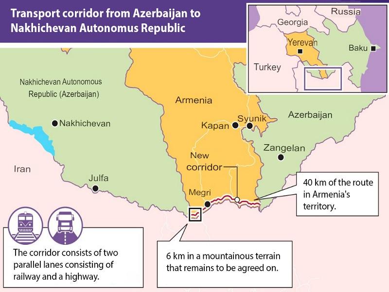
What This Map Shows
The visualization highlights a proposed corridor that would establish a connection between the two parts of Azerbaijan, facilitated by a partnership between the United States and Armenia. This corridor is strategically significant as it borders Iran, potentially altering geopolitical dynamics in the region. The map outlines the geographical layout of the corridor, emphasizing its proximity to key border areas and major transportation routes.
Deep Dive into Geopolitical Corridors
Geopolitical corridors are not just simple pathways; they are vital arteries that can influence trade, military strategy, and regional stability. This specific corridor aims to connect the two Azerbaijani territories, which are separated by Armenia—a long-standing point of contention in the South Caucasus region. What's fascinating is that these corridors often serve multiple purposes, from facilitating commerce to acting as a buffer zone in times of conflict.
Historically, Azerbaijan has been strategically important due to its location, sitting at the crossroads of Eastern Europe and Western Asia. The country has sought to enhance its connectivity to bolster economic development and strengthen its geopolitical stance. The introduction of this corridor signifies a shift in alliances and trade routes, particularly in light of rising tensions in the region.
The corridor could enable Azerbaijan to improve its trade relations with neighboring countries, including Turkey and Georgia, while also mitigating the influence of Iran, which borders the southern edge of the corridor. Have you ever wondered why trade routes are so crucial? They are not just about moving goods; they are about establishing influence and power in a region where energy resources and strategic positions are paramount.
Furthermore, the control of this corridor could allow the U.S. and Armenia to exert additional influence in the South Caucasus, a region that has seen fluctuating alliances and conflicts, particularly related to the Nagorno-Karabakh dispute. The potential development of infrastructure along this corridor may also include roads, railways, and energy pipelines, which could significantly enhance economic activity.
Regional Analysis
Analyzing the specific regions affected by this corridor reveals a complex tapestry of ethnicities, cultures, and political dynamics. The corridor runs through areas that are sensitive both historically and politically. For instance, the Azerbaijani territories of Nakhchivan and the mainland are separated by Armenian-controlled areas, which complicates transportation and trade.
Interestingly, the impact of the corridor will likely vary by region. Nakhchivan, being an exclave, has historically relied on Iran for access to the rest of Azerbaijan. With the new corridor, the dynamics may shift, allowing for more direct access to the mainland. This could lead to increased economic opportunities for residents in Nakhchivan, which has been isolated economically and politically.
In contrast, the regions of Azerbaijan adjacent to the corridor may experience increased military presence as tensions rise with neighboring Armenia and Iran. The presence of U.S. influence could also change the security landscape, either fostering stability or exacerbating existing tensions. The differing needs and perspectives of communities along the corridor will play a crucial role in determining its ultimate success or failure.
Significance and Impact
The significance of this corridor extends far beyond just the physical connection it offers. It represents a shift in regional power dynamics, with potential implications for international relations. As the United States engages more deeply in the South Caucasus, it may alter the balance of power in favor of Azerbaijan and Armenia, at least temporarily.
Moreover, the corridor could serve as a model for future geopolitical projects aimed at enhancing connectivity in conflict-prone regions. With the global economy increasingly reliant on efficient transport networks, the establishment of this corridor could set a precedent for similar initiatives worldwide. As we look to the future, it’s essential to consider the broader implications of geopolitical corridors: Will they lead to cooperation or further conflict? Only time will tell, but the establishment of this corridor is undoubtedly a critical development in the ongoing narrative of the South Caucasus.
In conclusion, the proposed corridor between Azerbaijan and Armenia, under U.S. oversight, is a complex issue that intertwines geography, politics, and economics. The map serves as a visual representation of these intricate dynamics, making it a crucial tool for understanding the region's future.
Visualization Details
- Published
- August 9, 2025
- Views
- 140
Comments
Loading comments...