Napoleon's Battles Map

Alex Cartwright
Senior Cartographer & GIS Specialist
Alex Cartwright is a renowned cartographer and geographic information systems specialist with over 15 years of experience in spatial analysis and data...
Geographic Analysis
What This Map Shows
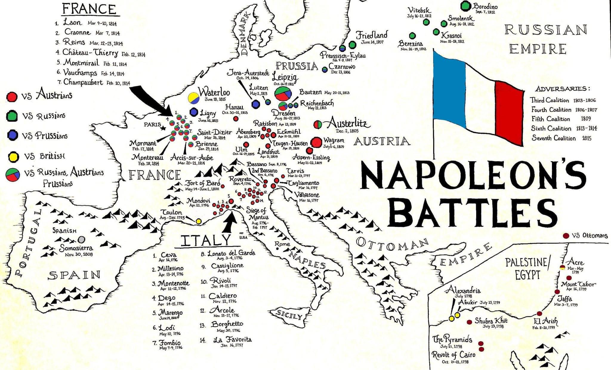
The "Napoleon's Battles Map" visualizes the major military engagements led by Napoleon Bonaparte during the Napoleonic Wars from 1803 to 1815. It highlights key battles, their locations across Europe, and the territories involved in these conflicts. This map serves as an excellent tool for understanding the geographical context of Napoleon's campaigns, allowing us to visualize not just the battles themselves but also the strategic movements and territorial ambitions of one of history's most renowned military leaders.
Deep Dive into Napoleon's Military Campaigns
Napoleon Bonaparte, a pivotal figure in European history, is often remembered for his military genius and the extensive empire he built. His campaigns were characterized by rapid movement, innovative tactics, and a profound understanding of logistics. What’s fascinating is how geography played a crucial role in shaping his strategies. The varied terrains of Europe influenced not only the deployment of troops but also the outcomes of battles.
One of the key elements of Napoleon's strategies was his use of the terrain to his advantage. For instance, the Battle of Austerlitz in 1805, often referred to as Napoleon's greatest victory, took place in a location that allowed him to exploit the weaknesses of the Austrian and Russian forces. The rolling hills and foggy conditions provided the perfect cover for his troops, demonstrating how geography can dictate military outcomes.
Moreover, Napoleon's campaigns were not just about direct confrontations but also about maneuvering to cut off supply lines and encircle the enemy. This tactical acumen is evident in battles such as the Battle of Jena-Auerstedt in 1806, where Napoleon's forces decisively defeated the Prussian army. The map illustrates how crucial road networks and river systems were in facilitating the movement of troops, allowing for rapid engagement or strategic withdrawal.
Interestingly, the extent of Napoleon’s campaigns also highlights the interconnectedness of Europe at the time. The map underscores how the borders of modern nations were often fluid, shifting as the Napoleonic Wars progressed. For example, the battles fought in the Iberian Peninsula, such as the Siege of Zaragoza, reveal the complexities of occupying foreign territories and managing local resistance.
Regional Analysis
Examining the map by region provides deeper insights into the impact of Napoleon's campaigns. In Western Europe, we see a concentration of battles in France, Belgium, and the Netherlands, reflecting Napoleon's efforts to defend and expand his home territory. The decisive engagements here, such as the Battle of Waterloo in 1815, signaled the end of his rule and had lasting implications for European politics.
In contrast, the Eastern Front, particularly the campaigns against Russia, reveals a different narrative. The disastrous invasion of Russia in 1812, marked on the map, not only represents a significant military defeat but also highlights the harsh climatic conditions and vast distances that Napoleon underestimated. The map indicates the route taken by his forces, illustrating the logistical nightmare of sustaining an army in such hostile territory.
Furthermore, the Southern regions, including Spain and Italy, exhibit the complexities of guerrilla warfare Napoleon faced. The Peninsular War was characterized by unconventional tactics employed by local forces, which the map brings to life by showing the spread of battles across the region. This aspect of his campaigns underscores how local geography and cultural factors can influence military success or failure.
Significance and Impact
Understanding Napoleon's battles is crucial not just for historical knowledge but also for comprehending the very fabric of modern Europe. The territorial changes resulting from his campaigns laid the groundwork for the nation-states we recognize today. The Congress of Vienna in 1815, which followed his defeat, sought to restore stability to Europe by redrawing boundaries, a direct consequence of the upheaval caused by Napoleon's ambitions.
Today, the legacy of these battles still resonates. Many European nations celebrate or remember key battles as part of their national history. Additionally, the strategic lessons learned from Napoleon's campaigns continue to influence military thought and doctrine. Have you noticed how modern military strategies still reflect the principles of mobility and maneuverability that Napoleon championed?
In conclusion, the "Napoleon's Battles Map" serves as a vital educational tool, providing insight into not just the military engagements but also the broader geographical and historical contexts that shaped Europe in the early 19th century. By studying these battles, we can better understand the evolution of warfare and the profound impact of geography on human conflict.
Visualization Details
- Published
- September 13, 2025
- Views
- 72
Comments
Loading comments...