Somaliland Territory Control Map

Alex Cartwright
Senior Cartographer & GIS Specialist
Alex Cartwright is a renowned cartographer and geographic information systems specialist with over 15 years of experience in spatial analysis and data...
Geographic Analysis
What This Map Shows
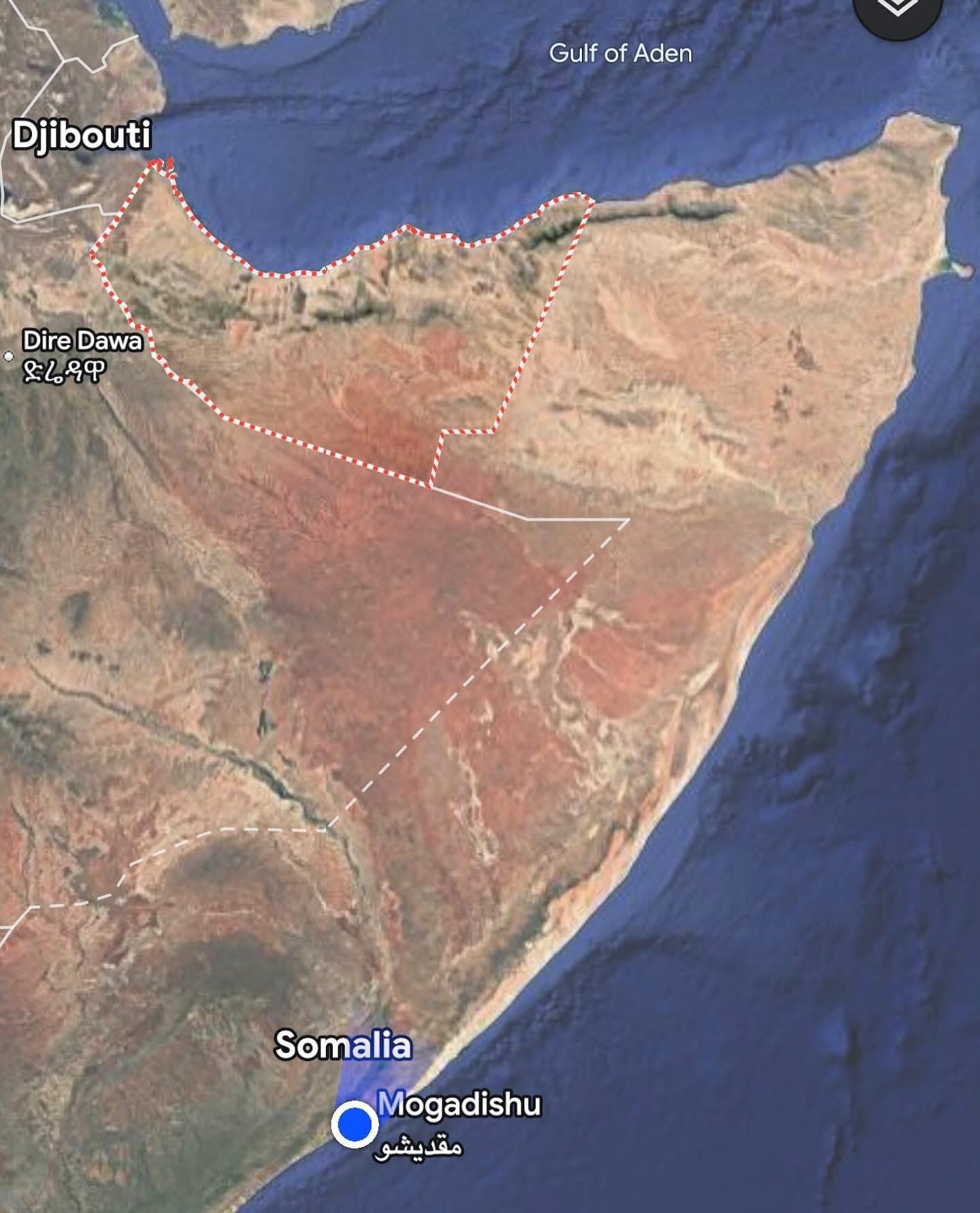
The "Google Maps updated Somaliland Territory" visualization reveals the current territorial control dynamics in the region, particularly the delineation between the areas effectively governed by the Somali government and those under the self-declared independence of Somaliland. This map serves as a critical tool to understand the ongoing geopolitical struggle within the Horn of Africa, showcasing the complexity of territorial claims and governance in a region marked by conflict and aspirations for autonomy.
Deep Dive into Somaliland's Territorial Dynamics
The territory of Somaliland, which declared independence from Somalia in 1991, has been a focal point of contention and regional identity. Interestingly, while Somaliland functions with a degree of autonomy and has established its own government structures, the Somali federal government maintains claims over the territory and currently controls about 30% of it. This complex relationship raises questions about identity, governance, and stability in the region.
In recent years, the Somali government has intensified its focus on the Somaliland issue, arguably prioritizing it over other pressing concerns like the fight against Al Shabab, the militant group that poses a significant threat to national security. This shift in focus could be viewed as an acknowledgment of the importance of resolving internal disputes to foster national unity and stability.
A particularly noteworthy aspect of this ongoing situation is the government's plan to carve out Awdal territory, located in the north, to create a new federal state. This proposal highlights the Somali government's strategy to decentralize power and provide greater autonomy to regions, which could lead to further fragmentation or, conversely, a more stable federal system.
The demographics of Somaliland are also crucial to understanding its territorial claims. The region is predominantly inhabited by the Isaaq clan, which has historically sought self-governance. By contrast, the areas under the Somali government’s control often have a more diverse ethnic composition, leading to varying perspectives on governance and allegiance. This demographic variation can significantly influence local politics and the potential for conflict or cooperation.
Regional Analysis
Examining the map closely, we can identify several key regions within Somaliland and the territories under Somali governmental control. For instance, the capital of Somaliland, Hargeisa, is situated in the northwest and acts as an economic and political hub. This city has witnessed a burgeoning infrastructure development program, highlighting its strategic importance to the self-declared republic.
In contrast, the southern regions, including areas like Las Anod, are more contested, with fluctuating control between Somaliland and the central Somali government. The governance of these regions often fluctuates due to the ongoing tensions between clans and the influence of external actors. The map illustrates these precarious lines of control, reminding viewers of the fragile nature of peace in Somalia.
Interestingly, the Awdal region, which the Somali government aims to designate as a separate federal state, has its own distinct cultural identity and economic challenges. Historically, it has been less developed compared to regions like Hargeisa, which raises questions about resource allocation and governance effectiveness if this new state is realized.
Significance and Impact
Understanding the territorial dynamics illustrated in this map is crucial for multiple reasons. Firstly, it highlights the ongoing struggle for autonomy and self-determination in Somaliland, which can resonate with other regions globally that face similar issues. The situation in Somaliland exemplifies how historical grievances and identity politics can shape modern governance and territorial claims.
Moreover, the implications of the Somali government’s focus on Somaliland could signal a broader shift in national policy that prioritizes regional autonomy, potentially leading to greater stability or further fragmentation depending on how negotiations unfold. As the government seeks to address the needs of various regions, including the proposed Awdal state, the map serves as a visual representation of the delicate balance between unity and division.
In conclusion, the "Google Maps updated Somaliland Territory" visualization not only informs us about the current territorial control but also invites us to consider the deeper socio-political implications of these divisions. As the region continues to evolve, this map will undoubtedly serve as a reference point for discussions on governance, identity, and conflict resolution in Somalia and the Horn of Africa as a whole.
Visualization Details
- Published
- September 8, 2025
- Views
- 86
Comments
Loading comments...