Turkey Libya Maritime Agreement Map

David Chen
Data Visualization Specialist
David Chen is an expert in transforming complex geographic datasets into compelling visual narratives. He combines his background in computer science ...
Geographic Analysis
What This Map Shows
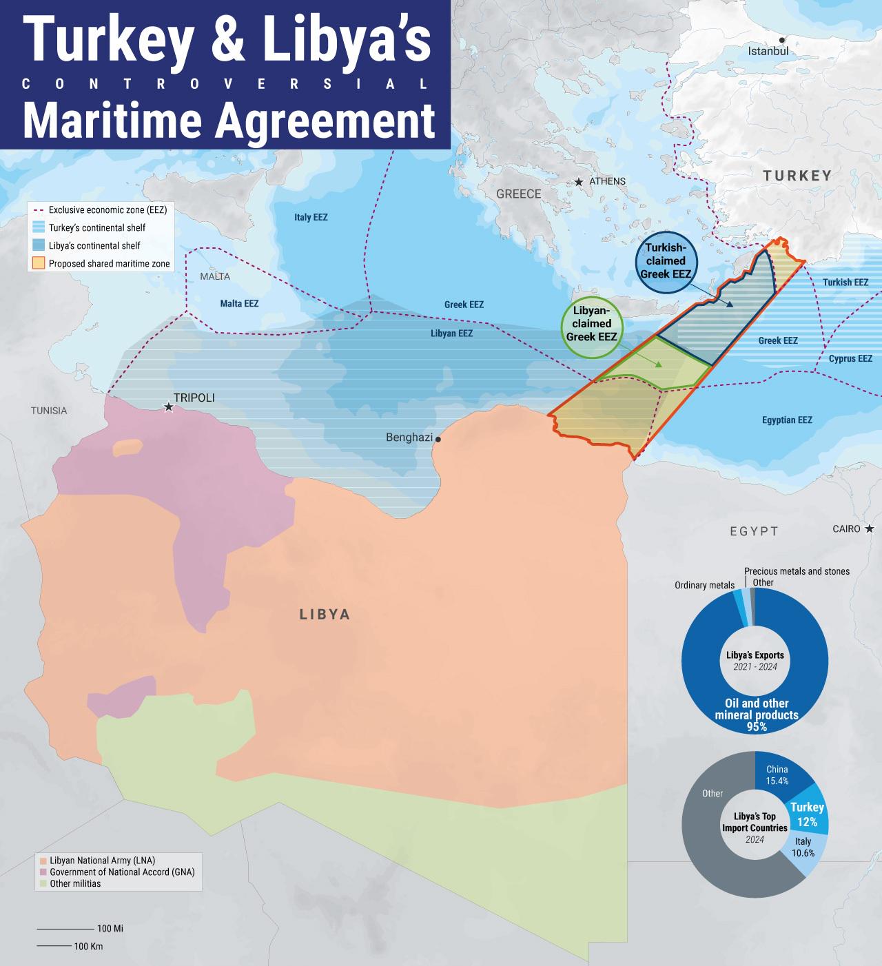
The visualization titled "Turkey & Libya's controversial maritime agreement (CBL/TurkStat/Liveumap)" illustrates the maritime boundaries and areas of contention between Turkey and Libya. This map highlights the regions where these two countries have laid claim to exclusive economic zones (EEZs) and maritime rights in the Eastern Mediterranean. It’s essential to understand that these areas are not just lines on a map; they represent national interests in energy resources, fishing rights, and geopolitical influence.
Deep Dive into Maritime Boundaries
Maritime boundaries are crucial in defining the extent of a nation's claims over oceanic resources. Turkey and Libya entered into a maritime agreement in late 2019 that delineated their respective maritime zones in the Eastern Mediterranean Sea. This agreement has stirred significant debate and controversy, not just in the involved countries but also across the entire Mediterranean region and beyond.
What's fascinating is that the Eastern Mediterranean is rich in hydrocarbon reserves, particularly natural gas. The discovery of these resources has heightened tensions among countries bordering the sea, including Greece, Cyprus, and Egypt, who also have competing claims to maritime territories. According to estimates, large gas fields have been found off the coasts of Cyprus and Israel, leading to a scramble for rights over these lucrative resources.
Turkey's agreement with Libya essentially aimed to provide a counterbalance to the claims made by Greece and Cyprus. By establishing this maritime boundary, Turkey sought to bolster its own position in the region, allowing it to explore and potentially exploit resources without interference from its neighbors. The agreement also emphasizes Turkey's strategic partnership with Libya, especially in the context of regional instability following the Libyan Civil War.
In essence, the map serves as a visual representation of the geopolitical chess game unfolding in the Eastern Mediterranean, showcasing not just territorial claims but also the underlying economic and political motivations driving these nations.
Regional Analysis
Looking more closely at the Eastern Mediterranean, the map highlights several key regions. For instance, southern Turkey and northern Libya have been focal points of this agreement, but the implications extend farther.
Turkey’s claims extend deep into what Greece and Cyprus consider their own EEZs, notably encroaching on areas rich in hydrocarbon deposits. This has led to increased military posturing and naval exercises in the region, heightening tensions.
Interestingly, Greece has responded by strengthening its alliances with other Mediterranean nations, like Egypt and Israel, to counterbalance Turkey’s influence. The map also reflects how these relationships are not static; they evolve based on broader regional dynamics. For example, in response to the maritime agreement, Greece has initiated agreements with Italy and Egypt to delineate their maritime boundaries, effectively isolating Turkey.
The map also highlights the complex nature of Libyan territorial waters, which are currently subject to internal divisions and varying degrees of control. The Libyan government, particularly the Government of National Unity (GNU), has relied on Turkey for military support, which further complicates the maritime landscape.
Significance and Impact
Why does this maritime agreement matter? The implications stretch far beyond mere territorial claims; they are intertwined with issues of national security, economic stability, and international relations. The Eastern Mediterranean is increasingly viewed as a critical area for energy security in Europe, especially in light of the European Union's goal to reduce dependence on Russian energy.
Moreover, the agreement has potential environmental impacts as increased drilling and exploration activities could threaten marine ecosystems in these already vulnerable waters.
Current trends indicate that the situation will remain fluid. As countries continue to negotiate their maritime rights, the potential for conflict remains high. Historically, disputes in the Mediterranean have led to heightened military presence and even armed confrontation. Therefore, understanding the map and its implications is crucial for anyone interested in the geopolitical landscape of the region.
In conclusion, the Turkey-Libya maritime agreement is not merely a legal document; it encapsulates a larger struggle for power and resources in the Eastern Mediterranean. As nations navigate this complex web of claims and counterclaims, the map serves as a vital tool for visualizing the ongoing dynamics at play and their potential ramifications for the future of regional stability.
Visualization Details
- Published
- August 30, 2025
- Views
- 78
Comments
Loading comments...