Kangnido Map (1402) World Map Analysis

David Chen
Data Visualization Specialist
David Chen is an expert in transforming complex geographic datasets into compelling visual narratives. He combines his background in computer science ...
Geographic Analysis
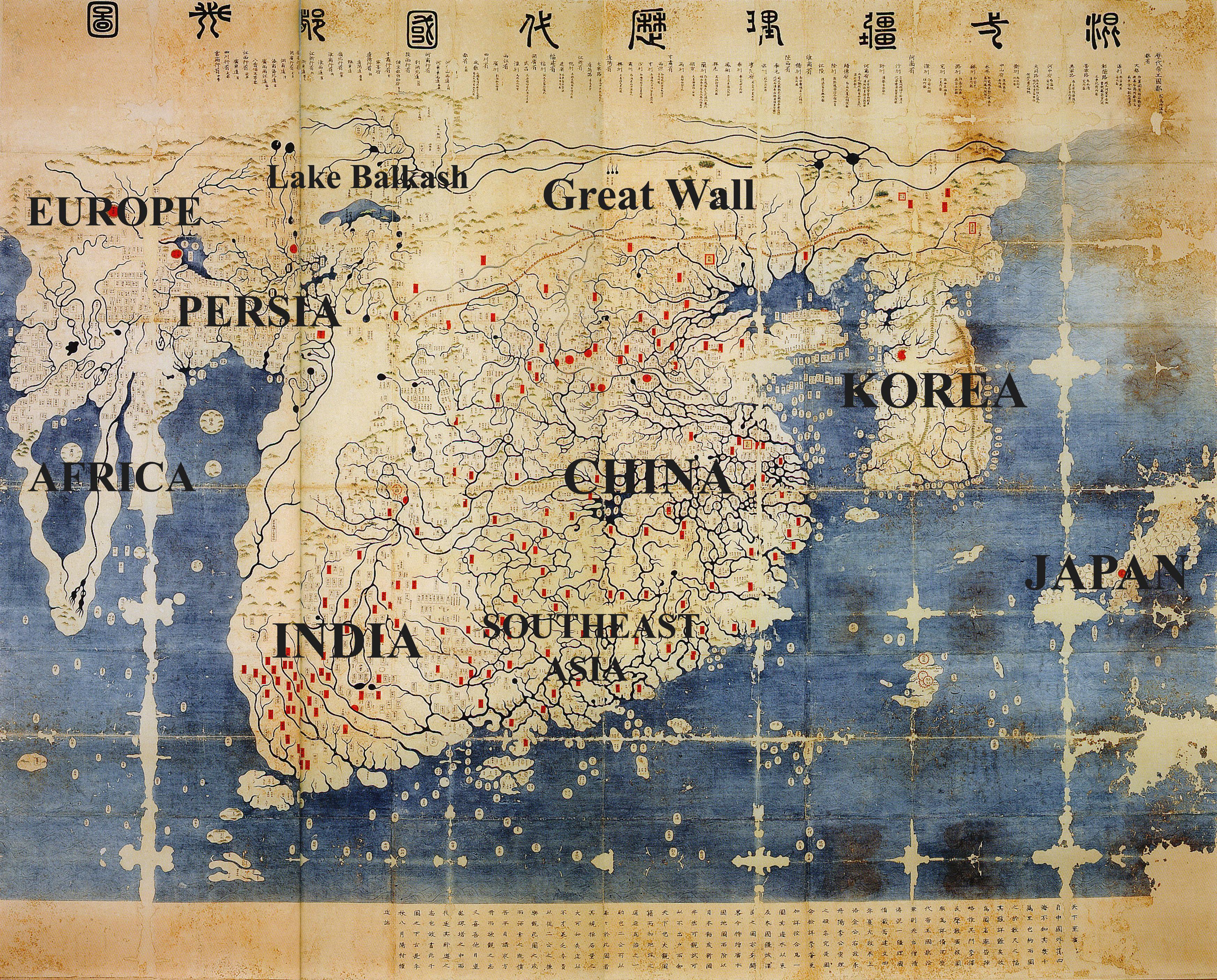
What This Map Shows\nThe Kangnido Map, created in 1402, is one of the earliest known world maps produced in Korea. This fascinating cartographic piece offers a unique perspective on how the world was perceived during the early 15th century, showcasing not only geographical features but also cultural and political boundaries of the time. The map is notable for its relatively accurate depiction of East Asia, including Korea, China, and Japan, while also attempting to represent regions as far away as Europe and Africa. What’s remarkable is how it reflects the geographical knowledge and worldview of its creators, merging both Chinese and Korean influences in its design.
Deep Dive into Cartographic Representation\nThe Kangnido Map is a treasure trove of information about the geographical understanding of the world in the early 1400s. One of the map's most striking features is its depiction of the landmasses and their proportions relative to each other. The map not only shows the major continents but also highlights significant rivers, mountain ranges, and cities that were known at the time. For instance, the Yangtze and Yellow Rivers are prominently featured, underscoring their importance in the cultural and economic life of China.
Interestingly, the map showcases the concept of the world as an interconnected entity, with trade routes and travel paths illustrated. This is critical because it indicates that the people of Korea were aware of and engaged in international trade, which was not only limited to their immediate neighbors but extended to far-off lands.
Moreover, the Kangnido Map is a blend of cartographic tradition and innovative representation. It combines the stylized approach common in Asian maps with a more realistic portrayal of certain geographical elements. The map uses a unique orientation, placing the South at the top, which may seem peculiar to modern viewers but offers insight into how different cultures conceptualize direction and geography.
This early world map also captures the political landscape of the time. The territories are often labeled in a way that reflects the dynastic power structures, which can give us a glimpse into historical territorial claims and relationships. The clear delineation of regions showcases how power was distributed and underscores the significance of certain cities as centers of culture and commerce.
Regional Analysis\nWhen examining the regions represented in the Kangnido Map, one can observe notable differences in the accuracy and detail provided. For instance, East Asia, particularly Korea and China, is depicted with a considerable degree of precision, demonstrating the mapmakers' familiarity with their own geography. The boundary lines and city placements reflect a deep cultural and political understanding of the region.
In contrast, areas such as Europe and Africa are less detailed, with some regions depicted more abstractly. For example, while the Mediterranean Sea is recognizable, many of the countries are labeled in a way that might confuse modern viewers. This discrepancy highlights the limitations of knowledge at the time and emphasizes how distant lands were often less understood.
Moreover, the inclusion of mythical elements, such as fantastical creatures or uncharted territories, points to the blend of reality and mythology in historical maps. This reflects not only the mapmakers' imaginative interpretations but also the limitations of their exploration capabilities. It’s intriguing to think about how these maps influenced perceptions of the world and how they served as both practical tools and sources of inspiration.
Significance and Impact\nThe Kangnido Map is significant not just as a historical artifact but also as a reflection of the cultural exchanges that were occurring during the medieval period. It provides valuable insights into the trade networks that were developing, as well as the ways in which different cultures interacted with one another. The map serves as a reminder of the interconnectedness of human societies, even in an era when travel was fraught with challenges.
What’s fascinating is how maps like the Kangnido influenced later cartographic traditions, paving the way for more accurate representations of the world as exploration expanded. They also highlight the importance of geography in shaping political and economic landscapes, something that is still relevant today. As we look towards the future, understanding these historical maps can provide context for current geopolitical issues and international relations.
In conclusion, the Kangnido Map of 1402 is more than just a visual representation of the world; it is a historical document that encapsulates the knowledge, beliefs, and cultural exchanges of its time. As we delve into the study of geography, maps like this one remind us of the complexities of our world and the ever-evolving nature of human understanding.
Visualization Details
- Published
- August 19, 2025
- Views
- 142
Comments
Loading comments...