Map of Kurdish Republic of Mahabad and Azerbaijan People's Government 1946

David Chen
Data Visualization Specialist
David Chen is an expert in transforming complex geographic datasets into compelling visual narratives. He combines his background in computer science ...
Geographic Analysis
What This Map Shows
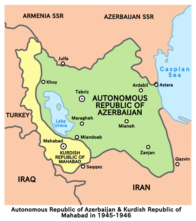
This map illustrates the geopolitical landscape of the USSR-backed breakaway Kurdish Republic of Mahabad and the Azerbaijan People's Government in northwestern Iran during the year 1946. It provides a visual reference to the territories claimed by these separatist entities following World War II and highlights the complex interplay of ethnic, political, and military forces in the region at that time.
The map delineates the borders of the Mahabad Republic, which emerged as a Kurdish nationalist state, and the Azerbaijan People's Government, a similar movement advocating for the rights of ethnic Azerbaijanis in Iran. Both of these regions were heavily influenced by Soviet support, which played a crucial role in their brief existence amidst the geopolitical tensions of the post-war era.
Deep Dive into the Kurdish and Azerbaijani Movements
The Kurdish Republic of Mahabad and the Azerbaijan People's Government were born out of a unique set of historical circumstances. Ever wondered why these movements gained momentum only after World War II? The answer lies in the fallout from the war and the subsequent power vacuum created by foreign interventions in Iran.
Following the Allied invasion of Iran in 1941, the political landscape shifted dramatically. The Soviet Union, in particular, sought to extend its influence in the region, promoting nationalist movements among various ethnic groups, including the Kurds and Azerbaijanis. This support was not merely ideological; it also included military aid and training, allowing these groups to establish their own governments in the face of Iranian authority.
Interestingly, the map reveals how the geography of the region influenced these movements. The mountainous terrain of western Iran is traditionally home to Kurdish populations, while Azerbaijanis primarily inhabit the northern regions close to the border with the Soviet Union. The natural divisions created by the Zagros Mountains and the Aras River not only shaped the cultural identities of these groups but also served as strategic considerations for their aspirations for independence.
The Mahabad Republic was declared in December 1945, with Qazi Muhammad as its leader. However, the republic faced immediate challenges, including military confrontations with Iranian forces and tensions within its borders. The Azerbaijani government, on the other hand, was established in Tabriz, aiming to unite Azerbaijanis under a single political entity. Both governments, however, were short-lived, as they were ultimately dissolved in 1946 following intense diplomatic negotiations and military pressure from the Iranian central government, supported by the U.S. and Britain.
The period was marked by violent clashes, resulting in approximately 2,000 casualties. This turmoil highlights the fragility of ethnic nationalism within a broader geopolitical context. The temporary successes of these movements led to significant questions about self-determination and national identity that resonate to this day.
Regional Analysis
The map provides a clear distinction between the territories claimed by the Kurdish Republic and the Azerbaijan People's Government. In the northwest, the Mahabad Republic encompassed key Kurdish cities such as Mahabad and Baneh, which served as cultural and administrative centers. The influence of Kurdish culture, language, and history is strongly present in these areas, which have historically been marginalized in the larger Iranian state.
Conversely, the regions controlled by the Azerbaijan People's Government included major urban centers like Tabriz, which has long been a hub for Azerbaijani culture and commerce. This area's demographics reflect a rich tapestry of ethnic diversity, with significant populations of Armenians and Persians, creating a complex societal fabric that has often been a source of tension.
Interestingly, the map also serves as a reminder of how political boundaries often do not align with ethnic ones. The delineation of the Kurdish and Azerbaijani territories does not fully encapsulate the aspirations of these groups, many of whom live beyond the borders shown on the map. This dynamic is critical to understanding the ongoing issues of ethnic conflict and national identity in the region today.
Significance and Impact
The significance of this map extends beyond a mere historical snapshot; it offers insights into the ongoing struggles of ethnic minorities in the Middle East. The events of 1946 set a precedent for how regional powers interact with ethnic movements, often leading to severe consequences for local populations.
In contemporary times, the legacy of the Mahabad Republic and the Azerbaijan People's Government looms large in discussions about Kurdish autonomy and the rights of Azerbaijanis in Iran. The unresolved issues of ethnic self-determination continue to fuel tensions in the region, particularly in light of recent geopolitical shifts and the resurgence of nationalist movements.
As we look to the future, understanding the historical context provided by this map helps to inform current debates over governance, identity, and the quest for autonomy among various ethnic groups in Iran and neighboring countries. The struggle for recognition and rights persists, making this map not just a relic of the past but a crucial part of the ongoing dialogue about identity and statehood in the region.
Visualization Details
- Published
- August 13, 2025
- Views
- 116
Comments
Loading comments...