Columbus Voyage Map of 1492

Marcus Rodriguez
Historical Geography Expert
Marcus Rodriguez specializes in historical cartography and geographic data analysis. With a background in both history and geography, he brings unique...
Geographic Analysis
What This Map Shows
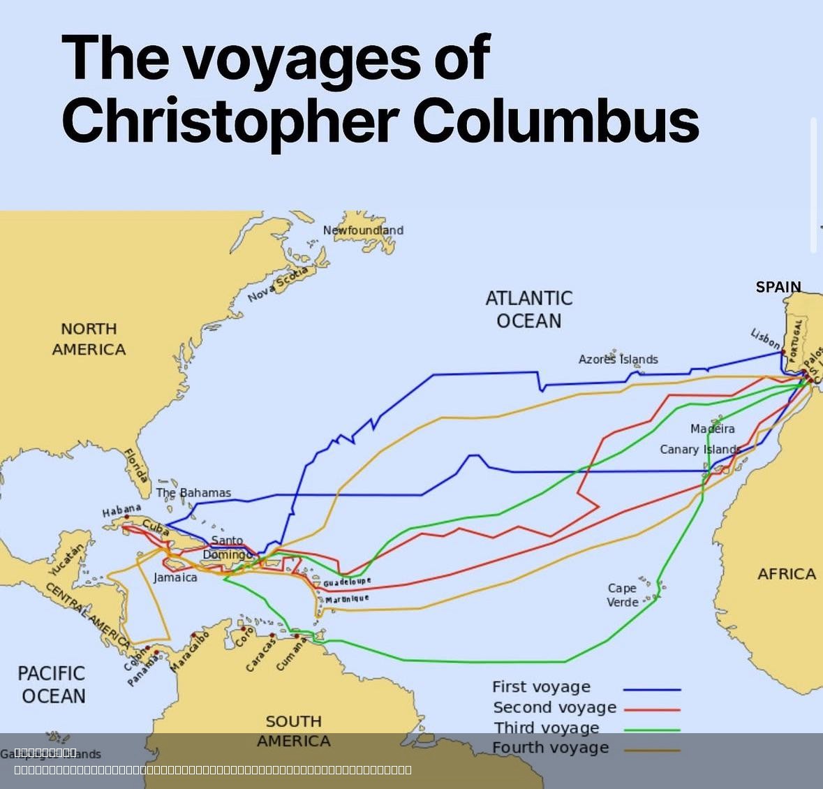
This map titled "In This Day in 1492, Columbus Started His Historic Voyage" illustrates the initial route taken by Christopher Columbus as he embarked on his journey across the Atlantic Ocean in search of a new trade route to Asia. The visualization details the departure point from Palos de la Frontera, Spain, the Canary Islands where Columbus made a brief stop, and the landfall in the Bahamas that marked the historic encounter with the New World. This fascinating map not only plots the path taken by Columbus but also serves as a window into the maritime navigation techniques and geopolitical context of the late 15th century.
Deep Dive into Maritime Exploration in the 15th Century
The late 1400s was a period of remarkable maritime exploration, driven by a desire for new trade routes and economic expansion. Columbus's voyage in 1492 was a pivotal moment in history, marking the beginning of European exploration and colonization of the Americas. At the time, European powers were eager to bypass the overland routes to Asia, which were controlled by various empires, including the Ottomans. This desire for direct access to spices, silk, and other valuable goods fueled a wave of exploration across the Atlantic.
Interestingly, Columbus's journey was not just a spontaneous decision; it was the culmination of years of planning and negotiation for royal support. The map shows how Columbus set sail with three ships—the Niña, the Pinta, and the Santa María—each designed for different purposes. The Niña and Pinta were caravels, small and fast ships ideal for exploration, while the Santa María was a larger carrack, used to carry supplies and serve as the flagship.
However, the voyage was fraught with challenges. Columbus faced not only the unpredictable nature of the Atlantic Ocean but also the skepticism of his crew, who feared they would sail off the edge of the world. Columbus's navigational skills were also put to the test as he relied on rudimentary tools like the astrolabe and compass, as well as dead reckoning to estimate their position. Despite these challenges, Columbus managed to chart a course that would ultimately lead him to the Bahamas, which he believed to be islands off the coast of Asia.
What's fascinating is that Columbus's maps at the time were based on classical knowledge and the limited geographical understanding of the world. The land he encountered was completely unknown to Europeans, and as such, it opened up a new chapter in global history, leading to the exchange of goods, cultures, and ideas—a phenomenon known as the Columbian Exchange.
Regional Analysis
Columbus's initial landing in the Bahamas marked the beginning of European contact with the Americas. The various islands of the Caribbean, which he explored, showcased diverse ecosystems and indigenous cultures that had developed over thousands of years. The map highlights the Bahamas, but it's important to note that the broader Caribbean region consists of numerous islands, each with its unique geography, climate, and biodiversity.
For example, the Greater Antilles, which include Cuba, Jamaica, and Puerto Rico, are characterized by larger land masses and varied topography, from mountains to coastal plains. In contrast, the Lesser Antilles are made up of smaller islands, often volcanic in origin, with lush tropical vegetation. This geographical diversity contributed to the rich cultural tapestry of indigenous peoples, including the Taíno and Arawak, who inhabited these regions long before Columbus's arrival.
In analyzing the map further, one can see how Columbus's voyage initiated a shift in global trade dynamics. The Caribbean became a crucial hub for European powers looking to exploit resources and establish colonies, leading to profound changes in the region’s demographics and ecology over the subsequent centuries.
Significance and Impact
The significance of Columbus's voyage extends far beyond the map itself. This journey set the stage for the Age of Discovery, a period that reshaped global trade, colonization, and cultural exchanges. Columbus's encounters with the New World led to the establishment of trade routes that would connect Europe, Africa, and the Americas in unprecedented ways, often with devastating consequences for indigenous populations.
Have you noticed how the legacy of Columbus's journey is still a topic of debate today? While many celebrate the exploration and the resulting cultural exchanges, there is a growing recognition of the negative impacts, including the spread of diseases and the colonization that led to the displacement and suffering of Native peoples. Current discussions about Columbus Day and Indigenous Peoples' Day reflect this complex legacy.
Looking ahead, the historical impact of Columbus's voyage continues to influence today's geopolitical landscape. The Caribbean, once a focal point for European powers, remains a region of strategic importance for trade, tourism, and environmental conservation. With ongoing discussions about climate change and its effects on island nations, the lessons from Columbus's time remind us of the interconnectedness of our world and the importance of responsible stewardship of our planet.
In summary, this map serves as a reminder of a pivotal moment in history, encapsulating the spirit of exploration that characterized the 15th century while also prompting us to reflect on the broader implications of those journeys.
Visualization Details
- Published
- August 3, 2025
- Views
- 122
Comments
Loading comments...