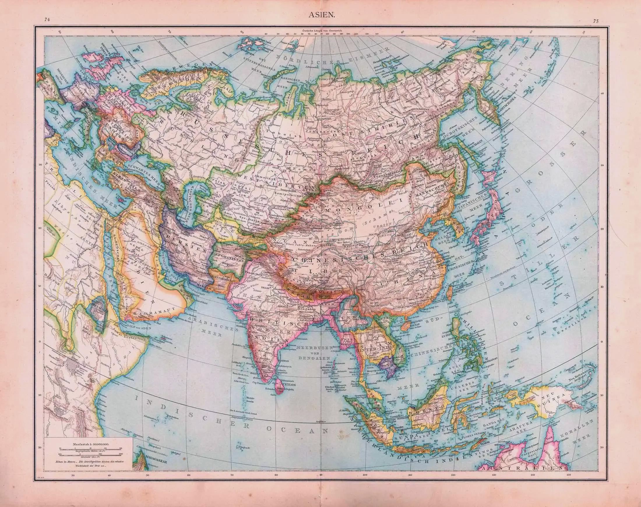
Political Map of Asia 1879


Alex Cartwright
Senior Cartographer & GIS Specialist
Alex Cartwright is a renowned cartographer and geographic information systems specialist with over 15 years of experience in spatial analysis and data...
Geographic Analysis
What This Map Shows
The "Asia (1879 political map)" offers a window into the geopolitical landscape of Asia during the late 19th century. This map displays national boundaries, colonial territories, and significant political entities of the time. It serves as a historical snapshot, capturing the complex relationships among various nations and colonial powers as they vied for influence and control over the continent's vast resources and strategic positions.
Deep Dive into Political Boundaries in Asia
The late 19th century was a transformative period for Asia, characterized by the decline of traditional empires and the rise of colonialism. The political divisions illustrated in this map reflect the tumultuous changes that were taking place during this era. The map prominently shows the British Raj in India, which was the crown jewel of the British Empire. This vast territory encompassed not only modern-day India but also Pakistan and Bangladesh, showcasing the influence Britain wielded over the Indian subcontinent.
Interestingly, the map also highlights the Qing Dynasty in China, which faced internal strife and external pressures. The Taiping Rebellion (1850-1864) and the subsequent Boxer Rebellion (1899-1901) were significant events that weakened the empire from within, while foreign powers, including Britain, France, Germany, and Russia, sought to carve out their own spheres of influence. The map illustrates the territories where these powers held dominion or influence, including areas in northeastern China and the strategically vital coastal cities.
Southeast Asia is depicted as a patchwork of colonial territories. The French controlled large portions of Indochina, while the Dutch dominated Indonesia. This colonial presence significantly affected the cultural and social fabric of these nations, leading to a blend of indigenous and foreign influences that continue to shape these societies today. The political map of 1879 serves as a reminder of how colonialism impacted governance, resource distribution, and national identity.
Furthermore, the Ottoman Empire's reach into Western Asia is visible, with territories that included modern-day Iraq, Syria, and parts of the Arabian Peninsula. This area, often referred to as the 'sick man of Europe' during this period, was gradually losing its grip on power as nationalist movements began to rise.
Regional Analysis
When examining the political landscape by region on this map, it's evident that there are stark contrasts in governance and territorial control. In East Asia, for instance, the map illustrates the Qing Empire's significant territorial expanse, yet it also hints at its vulnerability. The Japanese Empire, having undergone rapid modernization during the Meiji Restoration (1868-1912), is emerging as a formidable power in the region, soon to challenge both the Qing and Western colonial powers.
Southeast Asia presents a different scenario. The French, British, and Dutch colonial powers had established control over vast territories, yet local resistance was brewing. Countries like Vietnam were beginning to see the rise of nationalist movements aimed at regaining independence from colonial rule. This regional complexity is reflected in the boundaries drawn on the map, which often disregarded ethnic and cultural divides.
In Central Asia, the Russian Empire was expanding aggressively, with the map indicating its reach into territories that are now part of Kazakhstan, Kyrgyzstan, and Uzbekistan. This expansion was driven by both strategic interests and the desire to access resources and trade routes. The Great Game, a term used to describe the strategic rivalry between the British Empire and the Russian Empire for dominance in Central Asia, was unfolding during this era, with profound implications for the regional balance of power.
Significance and Impact
Understanding the political landscape of Asia in 1879 is crucial for grasping the historical context of contemporary Asia. The territorial boundaries established during this period have had lasting effects that resonate in today's political climate. For instance, many of the conflicts and disputes in areas like Kashmir, Taiwan, and the South China Sea can trace their roots back to colonial legacies and the arbitrary borders drawn by foreign powers without regard for ethnic or cultural affiliations.
Moreover, the map underscores the significance of colonialism in shaping national identities and statehood in Asia. As countries gained independence throughout the 20th century, they had to navigate the complex legacies of colonial rule, which often included artificial borders and diverse populations with conflicting interests. The impact of these historical developments continues to influence diplomatic relations, trade partnerships, and regional stability.
In conclusion, the "Asia (1879 political map)" serves as more than just a historical reference; it is a vital tool for understanding the intricate interplay of power, culture, and identity in Asia. As we look to the future, recognizing the historical context of political boundaries can inform our understanding of ongoing challenges and opportunities within the region.
Visualization Details
- Published
- September 2, 2025
- Views
- 88
Comments
Loading comments...