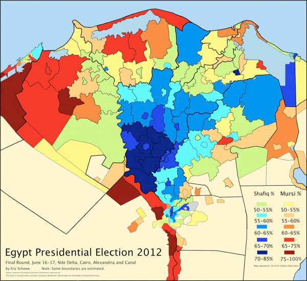
Egypt's 2012 Presidential Election Map


Marcus Rodriguez
Historical Geography Expert
Marcus Rodriguez specializes in historical cartography and geographic data analysis. With a background in both history and geography, he brings unique...
Geographic Analysis
What This Map Shows
The "Egypt's 2012 Presidential Election Map" provides a visual representation of the electoral outcomes across the country during a pivotal moment in its political history. It highlights the geographical distribution of votes among the various candidates, revealing how different regions of Egypt leaned politically during the election. This map is not just a collection of data points; it tells a story of a nation in transition, emerging from the shadows of the Arab Spring, with citizens eager to express their political choices.
Deep Dive into Egypt's 2012 Presidential Election
The 2012 Presidential Election in Egypt was a landmark event, occurring just a year after the ousting of President Hosni Mubarak. This election was crucial as it marked the first democratic presidential vote in the nation’s history. The map illustrates the results, particularly showing the support for the two leading candidates: Mohamed Morsi of the Muslim Brotherhood and Ahmed Shafiq, the last Prime Minister under Mubarak.
Interestingly, the election results displayed a deep geographical divide among voters. Morsi, representing the Islamist faction, garnered substantial support in rural areas, particularly in Upper Egypt, where conservative values and religious sentiments were more pronounced. In stark contrast, urban centers like Cairo and Alexandria leaned heavily towards Shafiq, indicating a preference for stability and a return to the military-backed governance that many believed Shafiq could provide.
According to the results, Morsi won approximately 51.7% of the vote, while Shafiq received around 48.3% in a tightly contested runoff. This narrow margin underscores the polarized political landscape in Egypt at the time. The map not only depicts the percentages of votes but also serves as a reminder of the socio-political factors influencing voter behavior. For instance, economic conditions, security concerns, and the legacy of Mubarak’s regime played significant roles in shaping the electorate's decisions.
Moreover, the electoral participation rates varied significantly across regions. Urban areas reported higher voter turnout compared to rural regions, reflecting differing levels of political engagement and access to information. Interestingly, this dynamic illustrates how urbanization and education levels can impact electoral outcomes, a trend that is often seen in various democracies worldwide.
Regional Analysis
When analyzing the map regionally, it becomes clear that Egypt's geography played a critical role in the election results. In the Nile Delta region, which includes key cities like Mansoura and Tanta, Morsi received significant support. This area is known for its agricultural base and a relatively high population density, which may explain the inclination towards the Muslim Brotherhood's promises of social justice and economic reform.
Conversely, regions such as the Red Sea governorates and parts of Cairo exhibited a preference for Shafiq. These areas, often driven by tourism and business interests, reflected a desire for economic stability and continuity, aspects that Shafiq’s campaign emphasized. The map reveals these contrasting preferences, showcasing not only political affiliations but also the underlying economic and social factors that contributed to them.
Interestingly, the map also highlights the role of the Coptic Christian community, particularly in urban areas. Many Copts favored Shafiq, fearing the rise of political Islam under Morsi. This demographic factor added layers to the election’s complexity and reflected broader tensions within Egyptian society.
Significance and Impact
The significance of the 2012 Presidential Election cannot be overstated. It represented a critical juncture in Egypt's post-revolutionary trajectory. The election results influenced the political landscape for years to come, leading to Morsi's presidency and subsequent political turmoil. This map serves as a historical document, illustrating not only who won and lost but also providing insight into the shifting tides of public sentiment.
The implications of these electoral outcomes resonate even today. The political divide highlighted in the map foreshadowed future conflicts, including the military’s eventual ousting of Morsi in 2013, which plunged the nation back into political uncertainty. Moreover, the map prompts us to consider how electoral geography shapes governance and societal dynamics. Have you noticed how electoral patterns often reflect deeper societal divides? This is certainly the case in Egypt, where the map reveals not just preferences but the hopes and fears of its people.
Looking ahead, understanding these electoral patterns is crucial for predicting future political developments in Egypt. As the country continues to navigate its post-revolution identity, the lessons gleaned from the 2012 Presidential Election are more relevant than ever, illustrating the challenges of building a stable democracy in a complex socio-political landscape.
Visualization Details
- Published
- August 19, 2025
- Views
- 100
Comments
Loading comments...