South African Republic Referendum 1960 Map


Marcus Rodriguez
Historical Geography Expert
Marcus Rodriguez specializes in historical cartography and geographic data analysis. With a background in both history and geography, he brings unique...
Geographic Analysis
What This Map Shows
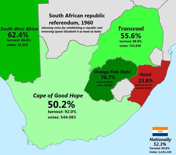
The "South African Republic Referendum 1960 Map" provides a visual representation of the regions in South Africa that participated in the referendum held on October 5, 1960. This pivotal event was centered around the question of whether the country should become a republic, ultimately severing ties with the British monarchy. The map highlights the geographic distribution of voter support and opposition, illustrating the divide that characterized the nation's political landscape during this era.
Deep Dive into the 1960 Referendum
The 1960 Referendum was a significant turning point in South African history. At the time, the country was under the control of the National Party, which had implemented the policy of apartheid, a system of institutionalized racial segregation. The referendum was a strategic move to consolidate power, presenting the republic as a more independent and sovereign entity.
Interestingly, the question posed to voters was deceptively simple: "Are you in favor of the Republic of South Africa?" However, the implications of this vote were profound. The referendum was primarily supported by the white electorate, particularly Afrikaners, who made up a significant portion of the voting population. The results showed a clear divide, with approximately 52% voting in favor of the republic and 48% against.
What’s fascinating is that the map visualizes not just the outcomes but also reflects the socio-political tensions of the time. Areas with higher concentrations of white populations, such as the Transvaal and the Orange Free State, displayed more support for the referendum, while regions with larger non-white populations, such as the Cape Province, showed significant opposition. This demographic split underscores the racial and cultural divides that were deeply entrenched in South African society.
The aftermath of the referendum saw South Africa officially becoming a republic on May 31, 1961. This shift brought about significant changes in governance and international relations, as the country moved further away from British influence. However, it also intensified internal conflicts, leading to increased resistance from anti-apartheid movements, which would gain momentum in the years to come.
Regional Analysis
Breaking down the map, we can observe distinct regional patterns in the referendum results. For instance, the Transvaal, home to a large Afrikaner population, showed overwhelming support for the republic, with towns like Pretoria and Johannesburg leading the way in votes favoring the transition. In contrast, the Cape Province, which had a more diverse population, exhibited resistance, reflecting the more liberal and multi-ethnic sentiments of the urban centers like Cape Town.
Interestingly, the Eastern Cape also had a notable divide. While predominantly rural and less populated, this region had a significant number of African communities that opposed the referendum. The map highlights these contrasts well, illustrating how geography played a role in the political sentiments of the time.
In comparison, the Free State, although smaller, mirrored the sentiments of the Transvaal with a high percentage of pro-republic votes. The map serves as a powerful reminder of how regional identities and demographics can shape political landscapes.
Significance and Impact
The significance of the 1960 referendum extends far beyond its immediate political implications. It marked a critical juncture in South Africa's journey towards a more entrenched apartheid system, which would lead to decades of struggle and conflict. The results of the referendum solidified the National Party's grip on power and set the stage for policies that would institutionalize racial discrimination.
Today, reflecting on this historical event through the map provides valuable insights into the complexities of South Africa's past. It highlights the importance of understanding how geography and demographics influence political decisions and public sentiment. The ongoing discussions around race, equality, and governance in South Africa can trace their roots back to these foundational moments.
As we analyze the current political climate in South Africa, it is essential to consider how the legacies of such referendums continue to impact the nation. Have you noticed that discussions around land reform, inequality, and social justice often echo the divides illustrated in this map? Understanding these historical contexts is crucial for grappling with present-day challenges and shaping a more equitable future for all South Africans.
Visualization Details
- Published
- August 17, 2025
- Views
- 130
Comments
Loading comments...