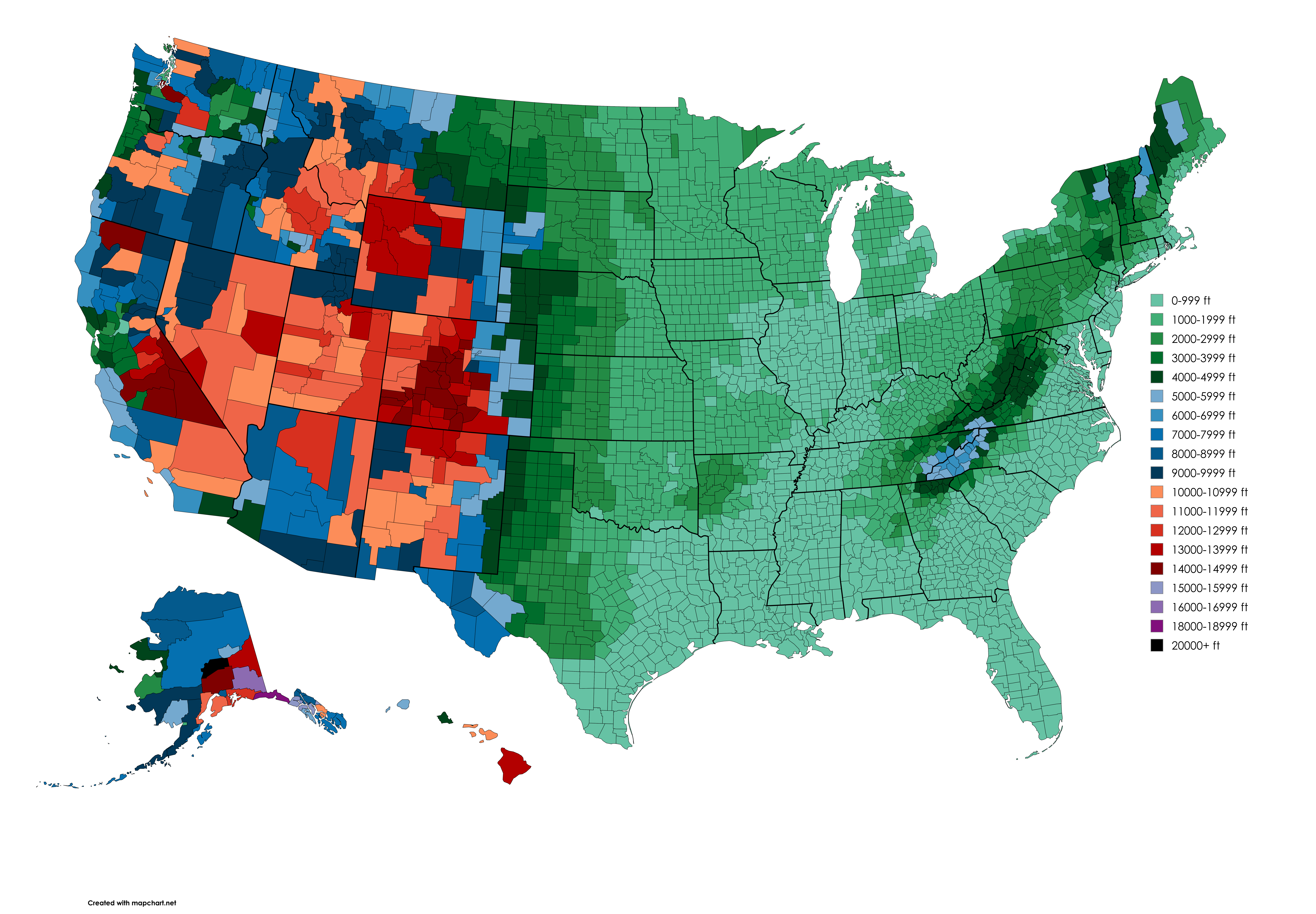
Highest Natural Elevation by US County Map


David Chen
Data Visualization Specialist
David Chen is an expert in transforming complex geographic datasets into compelling visual narratives. He combines his background in computer science ...
Geographic Analysis
What This Map Shows
The "Highest Natural Elevation by US County Map" provides a unique perspective on the topographical diversity across the United States. Each county is represented by its highest point, showcasing the varying elevations and geographical features that define each region. This visualization not only highlights the peaks and valleys within the country but also reflects how elevation contributes to the local climate, biodiversity, and even culture. From the rugged Rockies to the flat plains, elevation plays a crucial role in shaping the American landscape.
Deep Dive into Elevation and Topography
Elevation, defined as the height above sea level, is a fundamental characteristic of Earth's surface. It affects everything from weather patterns and ecosystems to human activity and infrastructure. In the United States, elevation varies dramatically, with the lowest point at Badwater Basin in Death Valley, California, at 282 feet below sea level, to the towering heights of Denali, the highest peak in North America, standing at 20,310 feet in Alaska.
Interestingly, elevation influences climate. Higher elevations generally experience cooler temperatures and distinct weather patterns. For example, counties in the Rocky Mountain region, such as those in Colorado and Wyoming, often see heavy snowfall in winter, while lower-elevation areas like those in Florida enjoy a subtropical climate. This variation leads to diverse ecosystems: alpine meadows in the highlands and wetlands in the lowlands, each supporting unique flora and fauna.
The highest points in counties across the U.S. range from notable peaks in national parks to less recognized hilltops. For instance, the highest point in Los Angeles County, California, is Mount Baldy, which rises to 10,064 feet. Conversely, the highest point in the flat terrain of Florida is only 345 feet at Britton Hill. This stark contrast illustrates not only the geographical diversity but also the cultural and recreational opportunities available, from hiking and skiing in mountainous regions to fishing and boating in coastal areas.
Moreover, elevation impacts human settlement and land use. Higher elevation areas often limit agriculture and urban development due to steep terrain and harsher climates, while lower elevation areas may experience population growth and urban sprawl. Have you ever noticed how cities like Denver thrive amidst the Rockies, with their unique blend of outdoor lifestyle and urban amenities? This dynamic creates a fascinating interplay between geography and human activity.
Regional Analysis
When we break down the map by regions, the differences in elevation become even more pronounced. In the West, states like Colorado and Utah showcase some of the highest elevations, with counties featuring peaks exceeding 14,000 feet. The San Juan Mountains in Colorado, for instance, have several counties with their highest points above 13,000 feet, making them hotspots for outdoor enthusiasts.
In contrast, the Midwest presents a flatter profile, with counties like those in Illinois and Indiana having their highest points around 1,000 feet. This lack of elevation change can lead to different agricultural practices and settlement patterns. Interestingly, the highest point in Illinois, Charles Mound, is a mere 1,235 feet, yet the region's fertile plains contribute significantly to the nation’s corn and soybean production.
The Southeast features a mix of moderate elevations, with the Appalachian Mountains influencing states like North Carolina and Tennessee. Here, the highest natural elevations can be found in counties that include parts of the Great Smoky Mountains, which not only boast stunning vistas but also a rich biodiversity that attracts millions of visitors each year.
Finally, Alaska and Hawaii present unique cases. Alaska's vast wilderness contains the highest elevations in the country, with Denali standing as a formidable giant. In contrast, Hawaii's highest peak, Mauna Kea, rises from the ocean floor, demonstrating how volcanic activity shapes island geography differently from continental landforms.
Significance and Impact
Understanding the highest natural elevations by county is more than just a geographic exercise; it has real-world implications. Climate change, for instance, poses significant risks to mountain ecosystems, with rising temperatures leading to glacial melt and altering water supply patterns. Moreover, as urbanization spreads, maintaining the balance between development and conservation in these varied terrains becomes increasingly crucial.
Furthermore, tourism is heavily influenced by elevation. Regions with higher elevations often attract tourists seeking adventure sports, such as skiing, hiking, and mountain biking, contributing significantly to local economies. However, this influx can also lead to environmental challenges, such as habitat disruption and increased waste.
In conclusion, the "Highest Natural Elevation by US County Map" serves as a valuable tool for understanding the interplay between elevation, climate, and human activity across the United States. By exploring these variations, we can appreciate the rich tapestry of America's geography and its profound impact on our lives.
Visualization Details
- Published
- August 16, 2025
- Views
- 108
Comments
Loading comments...