Prehistoric Coastline Influence on US Elections Map


David Chen
Data Visualization Specialist
David Chen is an expert in transforming complex geographic datasets into compelling visual narratives. He combines his background in computer science ...
Geographic Analysis
What This Map Shows
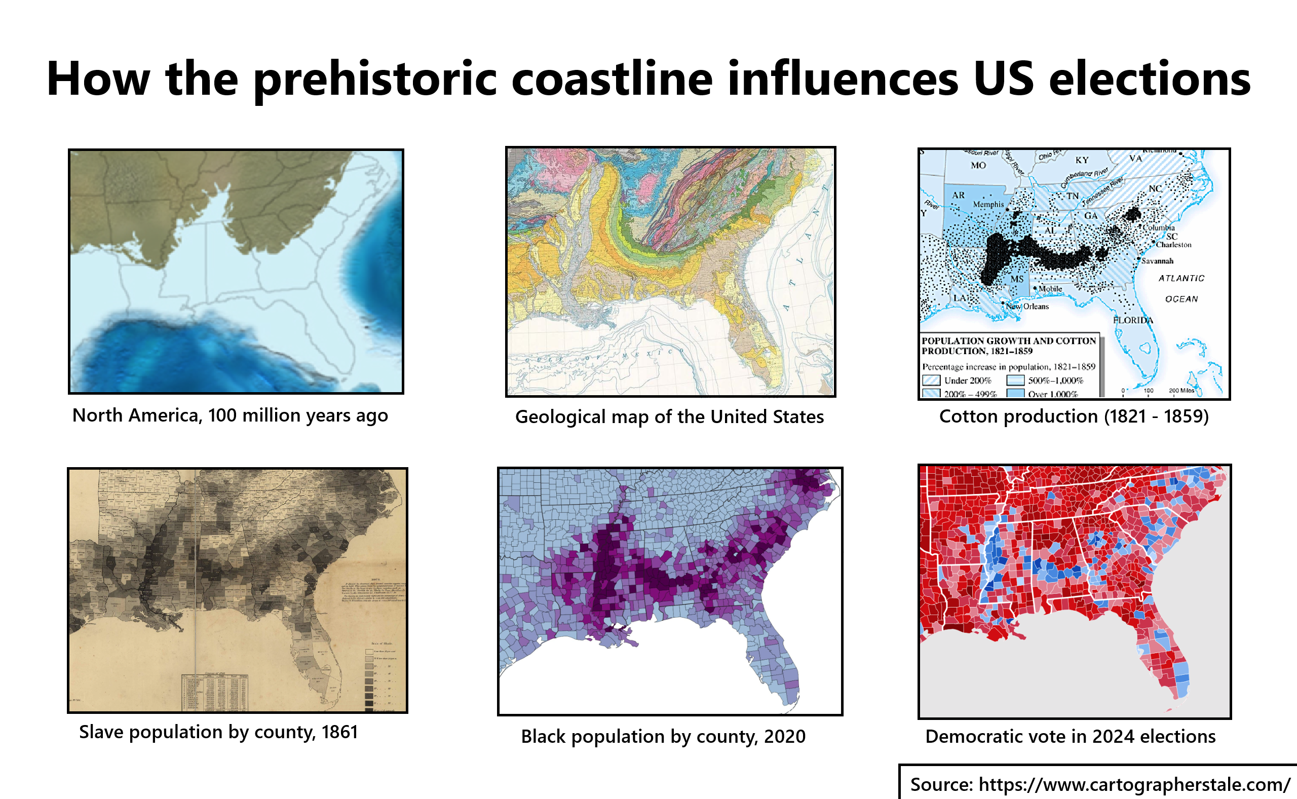
The map titled "How the Prehistoric Coastline Influences US Elections" provides a fascinating visual representation of how ancient coastlines, shaped by geological processes over millions of years, impact contemporary political landscapes across the United States. By juxtaposing this prehistoric geography against modern electoral data, we can begin to understand the deep-rooted connections between physical geography and political behavior. The visualization captures the extensive coastline that once existed, revealing how the shifting boundaries of land and sea have influenced settlement patterns, urban development, and ultimately, voting trends.
Deep Dive into the Prehistoric Coastline
Coastlines serve as crucial transition zones between land and sea, and their formation is a complex interplay of geological forces such as erosion, sediment deposition, and tectonic activity. The prehistoric coastline of the United States, for instance, has undergone significant changes since the last Ice Age. Throughout history, rising sea levels and climatic shifts have altered the layout of coastal regions, leading to varying degrees of accessibility to resources, trade routes, and habitation.
Interestingly, these ancient coastlines have left lasting impressions on demographic distribution. Coastal areas have historically attracted larger populations due to their access to maritime resources, trade, and transportation. This trend continues today, with regions along the Atlantic and Pacific coasts experiencing higher population densities compared to inland areas. The relationship between coastline geography and human settlement is a fundamental theme in geography, as it illustrates how natural features guide human choices and adaptations.
Moreover, specific geological features like bays, estuaries, and river deltas have played significant roles in shaping local economies and communities. For example, cities like New Orleans and Miami owe their existence and growth in part to their strategic coastal locations, which not only provide economic opportunities but also influence cultural and social dynamics. This raises an intriguing question: how do these coastal advantages translate into political power and electoral behavior?
Electoral outcomes can often reflect the demographic and socioeconomic profiles influenced by these ancient coastlines. Areas with robust economies, higher education levels, and diverse populations tend to lean towards specific political ideologies. In contrast, regions with less access to resources may display different political preferences. The contrast between coastal liberalism and inland conservatism can be traced back to these underlying geographical influences, highlighting how our environment shapes our values and political affiliations.
Regional Analysis
When analyzing the map, we can observe distinct trends across different regions. On the East Coast, states like California and New York have historically been strongholds for progressive politics, a trend that aligns with their coastal geography. Their large urban centers, which thrive on trade and diversity, often reflect a more liberal voting pattern. For instance, in the 2020 elections, both states showed significant support for Democratic candidates, a trend consistent with their urban coastal population dynamics.
In contrast, the Midwest and parts of the Southeast, characterized by their inland locations and different historical development paths, often lean Republican. States like Ohio and Indiana have been traditional battlegrounds, with political preferences shaped by factors such as agricultural economies, industrial history, and population migrations influenced by the prehistoric shoreline.
Interestingly, the South also presents a mixed picture. While coastal states like Florida showcase a blend of liberal and conservative voting patterns, driven by influxes of diverse populations, inland areas may stick to more conservative values, illustrating the nuanced influence of geography on political outcomes.
Significance and Impact
The connections between prehistoric coastlines and contemporary electoral outcomes are not merely academic; they have real-world implications. Understanding these geographic influences can inform political campaigns, urban planning, and resource allocation strategies. For example, recognizing that coastal cities face unique challenges related to climate change and rising sea levels can shape policy discussions and electoral platforms.
Additionally, as demographic shifts continue—whether due to urbanization, climate migration, or economic changes—political landscapes will evolve in tandem with the changing geography. What’s fascinating is that as we face new environmental challenges, the interplay between our physical landscape and the way we vote will only grow more complex. Can we predict future electoral outcomes based on these geographic trends? Perhaps, but it will undoubtedly require a keen understanding of both geography and human behavior.
In conclusion, the map demonstrating how prehistoric coastlines influence US elections is not just a visualization of ancient geography; it is a window into the interplay between our environment and democratic processes. By examining these connections, we can better appreciate the factors that shape our political system and the vital role geography plays in our collective future.
Visualization Details
- Published
- August 15, 2025
- Views
- 102
Comments
Loading comments...