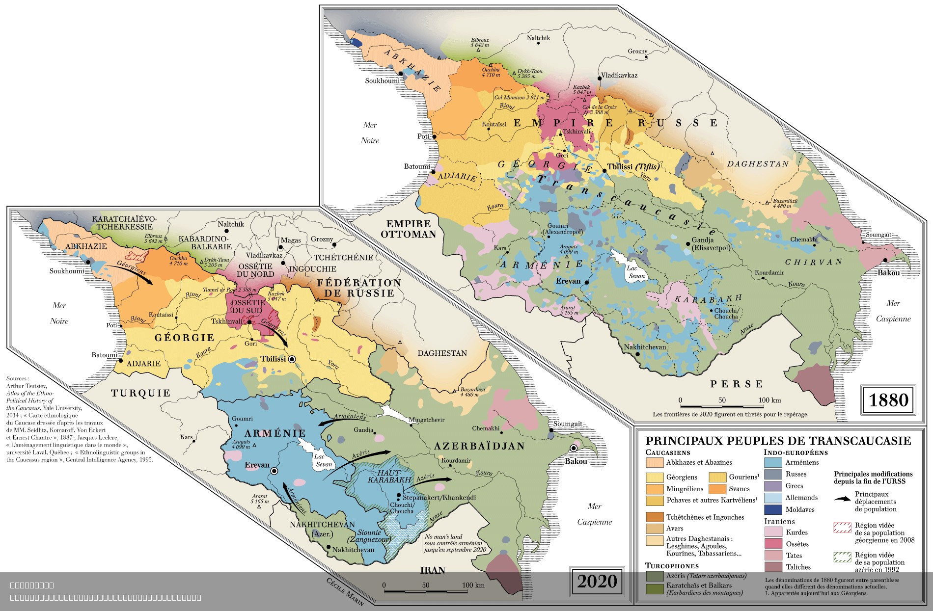
Ethnic Composition Map of Transcaucasia 1880-2020


Alex Cartwright
Senior Cartographer & GIS Specialist
Alex Cartwright is a renowned cartographer and geographic information systems specialist with over 15 years of experience in spatial analysis and data...
Geographic Analysis
What This Map Shows
The "Main Peoples of Transcaucasia 1880-2020" map provides a detailed visualization of the ethnic composition and distribution of populations across the Transcaucasus region over a span of 140 years. This area, nestled between Europe and Asia, encompasses the modern-day countries of Armenia, Azerbaijan, and Georgia. The map highlights how different ethnic groups have shifted in numbers and territorial presence, influenced by political, social, and cultural changes throughout history.
Transitioning from the visualization itself, let’s dive deeper into the ethnic dynamics that define this region.
Deep Dive into Ethnic Composition
The Transcaucasia region is known for its rich tapestry of ethnic groups, each with its own unique culture, language, and historical background. Historically, this area has been a melting pot due to its strategic location along trade routes and its role as a frontier between empires. The primary ethnic groups represented in this map include Armenians, Azerbaijanis, Georgians, and various smaller groups like Ossetians, Abkhazians, and Chechens.
From 1880 to 2020, the demographic landscape of Transcaucasia has seen significant transformations. For instance, Armenians primarily reside in Armenia, where they constitute about 98% of the population. However, during the late 19th century, significant Armenian populations were also present in parts of present-day Turkey and Azerbaijan, particularly in the Nagorno-Karabakh region. This territorial complexity has led to conflicts, especially during the 20th century.
Interestingly, Azerbaijanis, who comprise around 91% of Azerbaijan's population, also saw fluctuations in their numbers and distribution. The early 20th century marked a period of intense nationalism, which impacted the ethnic make-up significantly. During the Soviet era, borders were redefined, and many ethnic groups were settled or displaced, further complicating the demographic patterns that can be seen on the map.
Georgians, making up approximately 87% of Georgia's population today, have also faced demographic shifts. The country's turbulent history, including the civil war in the early 1990s and the 2008 conflict with Russia, has affected not only the Georgian populace but also the ethnic minorities such as Abkhazians and Ossetians, who have sought independence or integration into Russia.
The map illustrates these shifts vividly, showing how borders and demographic compositions changed during pivotal historical moments, such as the collapse of the Soviet Union in 1991, which led to the emergence of national identities and conflicts over territory.
Regional Analysis
Examining the map region by region reveals fascinating contrasts among the ethnic distributions. In Armenia, the overwhelming Armenian majority starkly contrasts with the multi-ethnic composition of Azerbaijan, where Azerbaijanis predominate but include significant minorities of Armenians, Lezgins, and Russians. The Nagorno-Karabakh region is particularly intriguing; over time, it has shifted from a majority Armenian population to a contested area post-1988, reflecting the intense geopolitical struggles of the region.
In Georgia, the ethnic composition is more complex, with Georgians, Abkhazians, and Ossetians coexisting in a delicate balance. The map sheds light on how these groups have moved and settled over the decades, often reflecting the political pressures of the era. For example, the South Ossetia region has seen a substantial increase in Ossetian populations, especially following the conflicts of the early 2000s, indicating a shift not just in numbers but also in territorial claims.
Significance and Impact
Understanding the ethnic composition of Transcaucasia is crucial for grasping the region's socio-political landscape. The historical tensions and conflicts, often rooted in ethnic identities, continue to influence contemporary politics and international relations. The ongoing disputes between Armenia and Azerbaijan over Nagorno-Karabakh are a direct consequence of demographic changes reflected in this map.
Moreover, as globalization continues to reshape borders and identities, the trends depicted in the map provide insight into future projections. For instance, the increasing movement of populations due to economic opportunities or conflict could further alter the demographic landscape. Ever wondered how these shifts might impact regional stability? As the world becomes more interconnected, the ethnic dynamics of Transcaucasia will undoubtedly play a significant role in shaping future geopolitical scenarios.
In summary, the "Main Peoples of Transcaucasia 1880-2020" map is not just a representation of ethnic groups; it’s a reflection of the historical, cultural, and political narratives that define this intriguing region. By understanding these dynamics, we can better appreciate the complexity and significance of Transcaucasia in both a historical and contemporary context.
Visualization Details
- Published
- August 7, 2025
- Views
- 88
Comments
Loading comments...