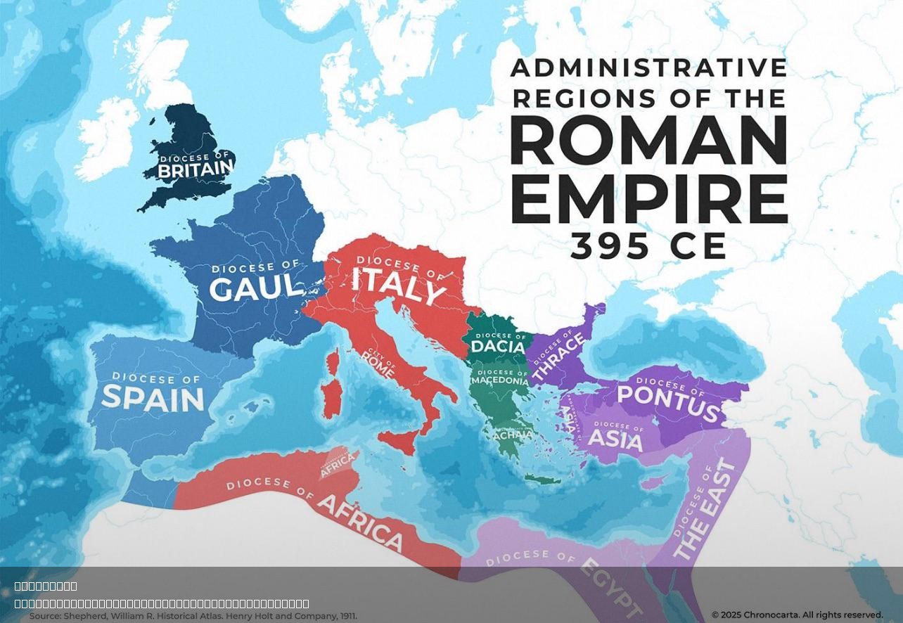
Administrative Regions of the Roman Empire Map


Marcus Rodriguez
Historical Geography Expert
Marcus Rodriguez specializes in historical cartography and geographic data analysis. With a background in both history and geography, he brings unique...
Geographic Analysis
What This Map Shows
The "Administrative Regions of the Roman Empire Map" provides a detailed representation of the vast territories governed by Rome at its peak. This visualization illustrates the different provinces and regions, highlighting their geographical boundaries, major cities, and the political divisions that characterized one of history's most influential empires. Understanding the layout of these regions is crucial for comprehending how the Romans managed such a diverse and extensive territory.
Deep Dive into the Administrative Structure of the Roman Empire
The Roman Empire, at its zenith around 117 AD, stretched from the British Isles to the sands of the Middle East, encompassing approximately 5 million square kilometers. This vast expanse was divided into several key administrative regions, known as provinces. Each province was governed by an official appointed by the emperor, often a senator or a former military leader, who was responsible for maintaining order, collecting taxes, and ensuring loyalty to Rome.
Interestingly, the administrative divisions of the Roman Empire were not arbitrary; they were often based on geographical features, cultural identities, and economic considerations. For instance, provinces like Gaul (modern-day France) and Hispania (Spain) were rich in resources and strategically important due to their locations along trade routes. The Romans implemented a systematic approach to administration, which included the establishment of roads, cities, and legal frameworks that facilitated governance and trade.
One of the most fascinating aspects of Roman provincial administration was the integration of local cultures and traditions. The Romans were adept at assimilating conquered peoples, allowing them a degree of autonomy while imposing Roman law and customs. This blend of cultures is evident in the archaeological remains found throughout the empire, from Roman baths in Britain to amphitheaters in North Africa.
The provinces of the Roman Empire included notable regions such as Britannia, Gallia, Germania, and Asia. Each of these provinces had unique characteristics that influenced their administration. For example, Britannia was known for its military presence and significant trade routes, while Asia, with its wealth and cultural diversity, served as a center for commerce and diplomacy.
Furthermore, the Roman legal system played a crucial role in the administration of provinces. Roman law, codified in the Twelve Tables and later the Corpus Juris Civilis, was implemented across the empire, ensuring a level of uniformity and justice. This legal framework not only facilitated governance but also helped to maintain peace and stability in a diverse empire.
Regional Analysis
Examining the map closely, we can see how the administrative regions varied significantly in size, population, and economic power. For instance, the province of Africa, which included modern-day Tunisia, was one of the wealthiest regions, thanks to its fertile land and agricultural productivity. In contrast, regions like Britannia were more militarized, reflecting the ongoing challenges of maintaining control over distant territories.
Another interesting comparison is between the provinces of Germania and Gallia. Germania, often viewed as a frontier province, faced constant threats from various tribes, leading to a heavier military presence. Meanwhile, Gallia became a critical hub for trade and culture, with cities such as Lugdunum (modern-day Lyon) flourishing under Roman influence. The differing administrative needs of these provinces highlight the Romans' adaptability in governance.
Significance and Impact
Understanding the administrative regions of the Roman Empire is crucial for several reasons. Firstly, it sheds light on how one of the most powerful empires in history managed to maintain control over such a vast and diverse territory for centuries. The Roman model of governance has influenced many modern political systems, particularly in terms of law, administration, and cultural integration.
Moreover, the legacy of Roman provincial administration is still evident today. Many modern European countries trace their administrative divisions back to ancient Roman practices. For instance, the concept of provinces or departments in France and Italy can be linked to Roman administrative regions.
Looking ahead, the study of these regions can provide insights into how empires rise and fall. In a world where globalization is increasingly prominent, understanding the dynamics of historical empires like Rome can help us navigate contemporary issues related to governance, cultural exchange, and economic collaboration. Ever wondered how the legacies of ancient civilizations shape our modern world? The Roman Empire's administrative strategies offer a compelling case study.
In conclusion, the "Administrative Regions of the Roman Empire Map" serves as a fascinating entry point into the complexities of one of history's most influential empires. By examining the map and understanding the underlying administrative structures, we can gain a deeper appreciation for how the Romans managed to rule over such a diverse range of peoples and cultures, leaving an indelible mark on the world that continues to resonate today.
Visualization Details
- Published
- August 7, 2025
- Views
- 200
Comments
Loading comments...