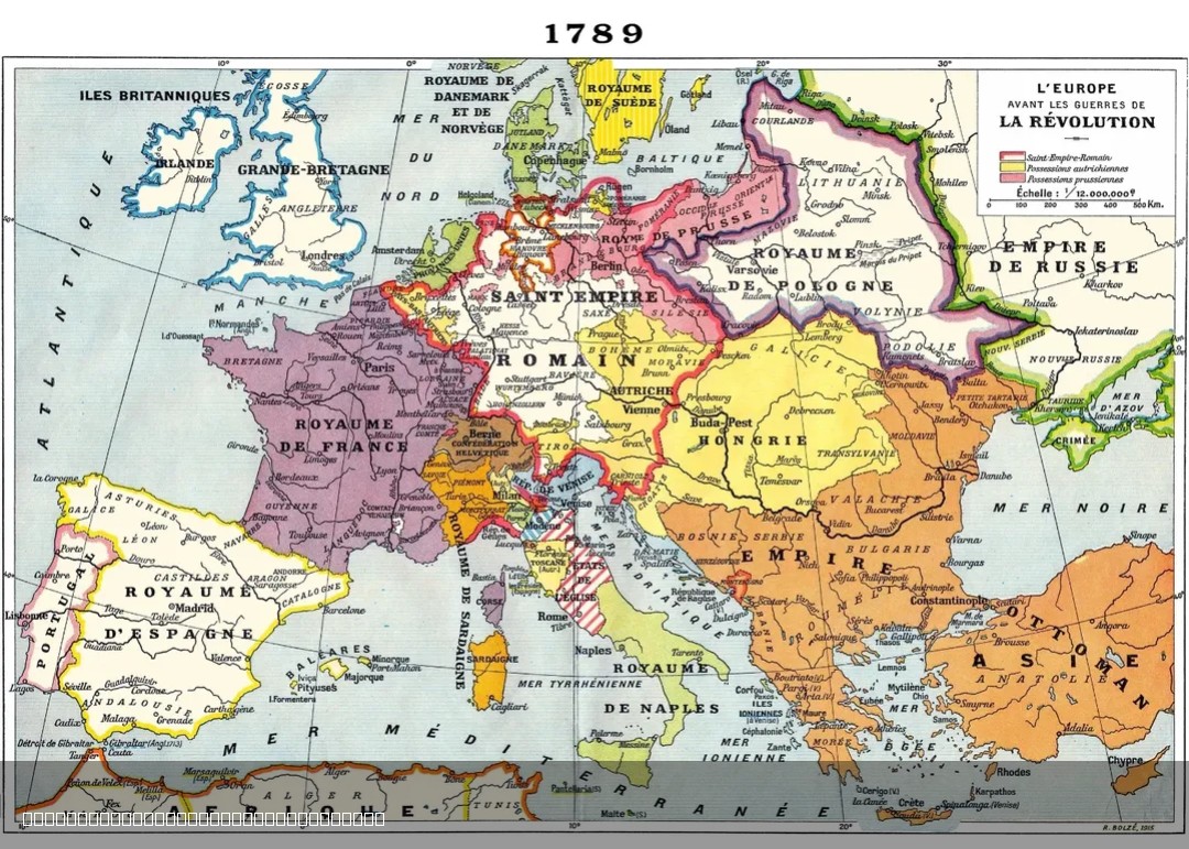
1915 French Map of Europe in 1789


Marcus Rodriguez
Historical Geography Expert
Marcus Rodriguez specializes in historical cartography and geographic data analysis. With a background in both history and geography, he brings unique...
Geographic Analysis
What This Map Shows
The 1915 French map of Europe in 1789 offers a historical perspective on the political landscape of Europe just before the French Revolution. It depicts the various territories, kingdoms, and regions that existed at that time, showcasing how the continent was divided and governed. The map is a fascinating representation of the socio-political dynamics that were in play during the late 18th century, illustrating the complex tapestry of alliances, rivalries, and cultural identities that characterized Europe prior to a period of monumental change.
Deep Dive into Europe in 1789
In 1789, Europe was a patchwork of monarchies, empires, and nascent republics, each with its own unique identity and governance. The map reveals the dominance of large empires such as the Habsburg Monarchy and the Ottoman Empire, alongside smaller principalities and duchies. Notably, France was a powerful kingdom on the brink of revolution, which would soon reshape not only its own destiny but that of Europe as a whole.
At this time, the Enlightenment was influencing political thought, leading to a growing desire for democracy and individual rights. The French Revolution would erupt shortly after, resulting in the fall of the monarchy and a radical shift in how Europeans viewed governance and citizenship. Interestingly, the map serves as a snapshot of a pre-revolutionary Europe, highlighting the tension between the old feudal structures and the emerging ideas of liberty, equality, and fraternity.
Geographically, the map also underscores significant natural features that shaped human settlement and political boundaries. Rivers such as the Rhine and Danube not only served as vital trade routes but also as natural borders between emerging states. The Alps acted as a formidable barrier, influencing the flow of culture and commerce between northern and southern Europe.
Regional Analysis
When we break down the regions depicted in the 1915 French map of Europe in 1789, we see clear distinctions in political and cultural identities. In Western Europe, France, the Netherlands, and the British Isles were experiencing a surge in revolutionary thought, contrasted sharply by the conservative monarchies of Spain and Portugal. The northwestern regions were marked by burgeoning commercial cities that were increasingly influential in shaping the political landscape.
Meanwhile, Central Europe was dominated by the Habsburg Empire, encompassing a mosaic of ethnic groups and cultures. The map illustrates a complex web of governance that included not just Austria but also Hungary, Bohemia, and parts of modern-day Italy. Each of these areas had distinct languages and cultural practices, often leading to tensions that would later manifest in nationalist movements.
In Eastern Europe, the map shows the vast expanse of the Ottoman Empire, which was beginning to show signs of decline. The Balkan region was a melting pot of ethnicities, and the map hints at the future conflicts that would arise from these diverse groups seeking autonomy. Notably, the presence of Poland is significant, as it had been partitioned among neighboring powers, reflecting the precarious nature of its sovereignty at the time.
Significance and Impact
Understanding the political landscape of Europe in 1789 is crucial for grasping the historical context of the French Revolution and its repercussions throughout the continent. The tensions depicted on the map foreshadowed the upheavals that would lead to the rise of nationalism and the eventual reconfiguration of borders in the 19th century.
Today, the legacy of this map is still evident in modern European politics. The nation-states that emerged following the revolutions and wars of the 19th century continue to influence international relations and cultural identities. What's fascinating is how the ideas of self-determination and governance that began to take root in 1789 are still relevant today, as many regions across the globe grapple with questions of national identity and autonomy.
In summary, the 1915 French map of Europe in 1789 is more than just a historical artifact; it is a critical piece of our understanding of how the past shapes the present. As we navigate contemporary issues of governance, cultural identity, and national boundaries, reflecting on this historical moment can offer valuable insights into the challenges we face today.
Visualization Details
- Published
- August 4, 2025
- Views
- 104
Comments
Loading comments...