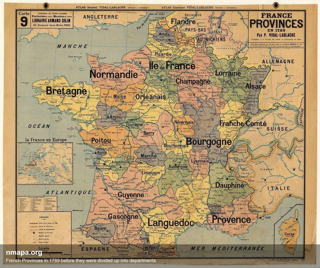
French Provinces Map of 1789


Alex Cartwright
Senior Cartographer & GIS Specialist
Alex Cartwright is a renowned cartographer and geographic information systems specialist with over 15 years of experience in spatial analysis and data...
Geographic Analysis
What This Map Shows
The 'French Provinces in 1789 before they were divided up into departments' map provides a visual representation of France's administrative boundaries just prior to the significant changes that would follow the French Revolution. It highlights the provinces as they were known at the time, each with its unique cultural and historical identity. Understanding this map is essential for grasping not only the geographic layout of France in the late 18th century but also the socio-political context that led to the transformation of these provinces into departments.
Deep Dive into French Provinces
The provinces of France in 1789 were more than mere geographical areas; they were steeped in history, tradition, and local governance. Interestingly, these provinces were often based on medieval territorial divisions and reflected the historical power struggles and alliances that shaped France. For instance, Brittany, with its Celtic roots, had a distinct cultural identity, while regions like Normandy were known for their agricultural productivity and maritime trade.
In total, France was divided into about 32 provinces at this time, each varying significantly in size, population, and economic activity. For example, the province of Île-de-France, which encompasses Paris, was one of the most populous and economically vibrant areas. In contrast, the more rural provinces like Limousin or Auvergne had lower population densities and were primarily agrarian.
The provincial system also facilitated local governance through a council of notables, which allowed for a certain degree of local autonomy. However, the tensions among these provinces often revolved around economic disparities and political representation. The wealthier provinces, particularly those surrounding Paris, often dominated political discourse, leading to grievances from the poorer provinces.
Moreover, the provinces were characterized by a patchwork of languages and dialects, showcasing the diverse cultural fabric of France. From the Breton language in the northwest to the Occitan dialect in the south, these linguistic differences contributed to a distinct regional identity that was deeply tied to local customs and practices.
Regional Analysis
When breaking down the provinces shown on the 1789 map, you can observe striking contrasts. Take, for instance, Provence and its neighbor Languedoc. Provence, famous for its lavender fields and Mediterranean climate, was a hub of trade and tourism, attracting visitors long before the rise of modern tourism. In contrast, Languedoc, while also rich in agriculture, had a more diverse economy that included viticulture, which would later become vital in the global wine market.
Additionally, the northern provinces like Picardy and Champagne were crucial for France’s military history, given their proximity to the borders and their strategic importance. These regions had fortified towns and were often battlegrounds during various conflicts in French history. On the other hand, the western provinces such as Brittany and Normandy focused on maritime activities and trade routes, which shaped their economies and cultural exchanges with England and other neighboring regions.
Interestingly, the disparities among these regions contributed to the revolutionary fervor that swept through France. The wealth inequality and lack of representation for the rural provinces led to a collective demand for change, culminating in the revolutionary movement that sought to abolish the provincial system altogether.
Significance and Impact
Understanding the French provinces in 1789 is crucial for comprehending the subsequent changes that shaped modern France. The division of provinces into departments in 1790 was a strategic move aimed at rationalizing governance and ensuring more equitable representation across regions. This shift marked a significant transition from historical identities to a more standardized bureaucratic framework.
The implications of this transformation extended beyond administrative boundaries. It laid the groundwork for modern French nationalism, as the new departmental system fostered a sense of unity among diverse groups. However, it also sparked debates about regional identities that persist to this day.
Today, the legacy of these provinces can still be felt in the cultural practices, dialects, and even the culinary traditions that vary across France. As we look at contemporary France, it's fascinating to see how historical divisions continue to influence regional pride and identity. Have you ever noticed how certain dishes or festivals are unique to specific regions? This rich tapestry of history that originates from the provinces of 1789 is still very much alive in the cultural landscape of France today.
Visualization Details
- Published
- August 2, 2025
- Views
- 172
Comments
Loading comments...